- Air Homepage
- Weather Radar
- National Radar Weather
National radar weather difficulties
National radar weather use optical instruments, which have problems like other optical tools. When light passes through an instrument, it will reflect and refract, resulting in inaccurate readings. Reflection and refraction are minimized by using multiple lenses and mirrors on the instrument.
Search for more weather radar.
Weather Radar's Real Problems: Behind the Blips - Weather radar doesn't always show the truth because invisible atmospheric tricks like ducting and inversions can make false ghost echoes or hide the real danger! Find out why mountains, melting snowflakes, and even the earth's curvature can cause errors like blocking, bright bands, and overshooting, making it crucial to know what you're really seeing when a storm approaches.
Fiber-optics, for instance, work by sending light down a glass duct. Because of the sharp changes in density, index of refraction, and curvature at the boundary, none of the energy gets out. As a result, we have a very efficient medium.
Sometimes, though, light escapes where we don't want it to and efficiency suffers. False signals can be caused by stray light entering or reentering the system. Radar imagery can be messed up by a lot of limitations and artifacts.
Why do we want to know more about weather radar problems?
Understanding weather radar technical problems can help you make better decisions about how to prepare for upcoming weather conditions by interpreting the data provided by the radar. It can also help you troubleshoot any potential problems with weather radar if you know the technical stuff.
Problems and technical difficulties on the national radar weather
The same principles can affect the national radar weather data in the first three examples. Anomaly propagation, AP, results from them.
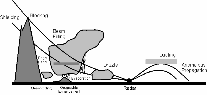
Here are brief explanations of each of these weather radar problems shown in the diagram below:
- When mountains or tall buildings block the radar signal, the radar can't see what's behind them. Thus we have shielding by solid objects.
- In blocking, precipitation or other objects in the atmosphere block the radar signal, making it hard for the radar to detect what's beyond them.
- Radar beam filling happens when the radar beam is too wide to measure precipitation particles accurately, making interpretation tricky.
- It's when radar waves reflect off melting snowflakes, creating a bright band in the radar image.
- Overshooting: When a thunderstorm pushes upward so strongly that the top of the storm rises above the radar's scan altitude, causing the image to be distorted.
- When air is forced up over mountains, it cools and condenses into clouds and precipitation. Rainfall amounts can be higher near mountains because of this orographic enhancement.
- There's something called drizzle. It's light rain that falls in very small droplets that are hard to detect with radar, because they don't reflect the signal very well.
- Ducting is when layers of air with different temperatures and moisture levels bend the radar signal, causing it to travel farther than it would normally, creating false radar echoes.
- Radar anomalous propagation: When the radar signal interacts with layers of air with different densities, it bends and creates false echoes.
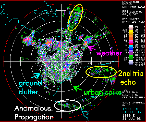
- A second trip echo (shown above) happens when radar beam reflects off an object, like a building or mountain, and then reflects off the ground or another object before returning to the radar antenna. It can make a second radar echo appear behind the original object.
When a radar beam hits a tall building and then reflects off the ground, it may create a second trip echo behind the building on the radar display. Radar operators can get confused by this because it looks like there's precipitation behind the building when it's actually just radar artifacts.
It's also possible to get second trip echoes when a radar beam reflects off other things in the environment, like trees or hillsides, before reflecting off the ground and returning to the radar antenna. Radar operators are trained to spot and account for these types of artifacts.
On an animated radar weather display, these show up as bright areas that sometimes dance around. Weather pictures can sometimes be seen from a long way away. Why? Reflecting boundaries are caused by:
- Radiation at night and nocturnal inversions - On clear nights, the temperature rises with height. Reflections from inversions can make radar depictions and distant radio stations look ghostly. As a kid, I used to listen to Vancouver radio in Medicine Hat, a thousand kilometres away. Due to internal reflection from an upper horizontal boundary, it worked late at night.
- The extra moisture near a cool water surface gives the same result as longwave inversions.
- Changes in temperature and humidity like those near a thunderstorm. When the local weather radar is most needed, this can distort the storm's image.
- Temperature and humidity increase simultaneously with height. Then sub-refraction can happen. It's also possible that the national radar weather signals get lost in space. In this case, we may never see them.
- When precipitation freezes or melts while falling. On radar, it looks like a glossy boundary. This is what meteorologists call the bright band.
- Radars leak radiation all the time, in several directions. Objects behind the radar, for example, can look like they're in front. It picks up reflected signals without figuring out their direction.
Go back from National Radar Weather to the Radar Real Time Weather
#8
webpage, or take a trip to the Stuff in the
Air homepage.
Search this site for more information now.
What Imperfections Might You See on National Radar Weather?
Be sure to check your local weather radar carefully. There are technical problems with the radar pictures on the national radar weather service. These unusual distortions may affect the images.
Do you have concerns about air pollution in your area??
Perhaps modelling air pollution will provide the answers to your question.
That is what I do on a full-time basis. Find out if it is necessary for your project.
Have your Say...
on the StuffintheAir facebook page
Other topics listed in these guides:
The Stuff-in-the-Air Site Map
And,
Thank you to my research and writing assistants, ChatGPT and WordTune, as well as Wombo and others for the images.
OpenAI's large-scale language generation model (and others provided by Google and Meta), helped generate this text. As soon as draft language is generated, the author reviews, edits, and revises it to their own liking and is responsible for the content.


New! Comments
Do you like what you see here? Please let us know in the box below.