- Air Homepage
- Upper Atmosphere
- Weather Convection Currents
Unstable weather convection currents
What happens when weather convection currents are at work? It's been a while since you've seen tall clouds. What causes a change in atmospheric stability? Is it possible to predict? How?
Search for more about meteorology.
Atmospheric Convection: The Hidden Ladder ☁️Have you ever wondered how a tiny pocket of air becomes a giant thunderstorm cloud? You'll learn how to identify the Level of Free Convection and predict when a small breeze will turn into a buoyant storm current by learning the precise scientific levels that govern atmospheric stability.
The temperature gradient, which is the difference in temperature between the surface and higher altitudes, is crucial to atmospheric stability. When the temperature gradient is big, the air is more unstable and tall clouds form easier. Using weather models and forecasting the temperature, you can predict the temperature gradient and thus atmospheric stability.
Let's start with the weather balloon. It carries a radiosonde that gives us an instant picture of the temperature above us. It takes an hour or two for it to reach its full altitude.
In the layers above, the profile tells us where the stable and unstable regions are. This helps us figure out where weather convection currents will be encouraged or dampened. Meteorologists use it to predict turbulence, clouds, and even severe storms.
Weather convection currents and static stability
Under these conditions, it happens. Left to its own devices, a situation will return to its original state if something forces it to. Try pushing your car up an incline without braking. It'll roll back down.
In Greek mythology, Sisyphus was punished by the gods, by pushing a car up a hill, only to have it roll back down. It symbolizes the futile and repetitive nature of human struggles and the search for meaning.
Don't be like him...Instead, call a tow truck. This driver can take it up the hill where it sits on level ground and it won't roll back down. There's one thing that makes fluids unstable: the air moves and changes - something hills don't have. To stay current, you need two radiosondes a day.
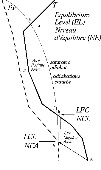
Take some air and see what happens if convection currents move it up or down. The simulation is done on a thermodynamic graph like a skewT or tephigram. The rest of the air is undisturbed.
Standard Adiabatic Lapse Rate
As we go up, the subject air parcel loses pressure, and the temperature falls at a standard, specific rate. Dry adiabatic lapse rate.
Moisture complicates things; it makes convection currents more likely. Particularly if there's enough water vapor to saturate the parcel.
We use the pseudo-adiabatic lapse rate (the saturated adiabat curve) through this part of the parcel's upward journey. Graphs of thermodynamics show curved lines sloping UP to the LEFT.
Note the intersections labelled LCL and LFC. The lifting condensation level (in English, LCL) and the level of free convection (LFC) are both important concepts related to air parcels moving vertically.
LCL is when a parcel of air becomes saturated and condenses into a cloud when lifted. It's when air rises and cools due to adiabatic processes and condensation starts. Below this point, the air parcel would have been following a a dry adiabat. LCLs are usually lower than free convection levels.
In contrast, the LFC is the level in the atmosphere where an air parcel can rise freely without any help needed, such as a wind or hill driving it upward. Due to its buoyancy, the air inside the parcel is warmer than its surrounding environment, so it will continue to rise on its own.
As the parcel rises, it gets warmer than the surrounding air in this example, which makes it unstable. As a result, the surrounding air pushes the parcel even higher and convection clouds form.
The equilibrium level (EL) is when the parcel gets cooler than the air around it by finding itself in warmer air. It then loses its internal drive and becomes stable at the top of the cloud. Most of these currents reach their EL before the stratosphere, where surrounding air temperature always increases with height.
Then what happens?
At this point, the parcel may be pushed back down if it becomes cooler than the air nearby and then we have stability. Moving downwards can also meet mechanisms that act in reverse and those moving upwards which can also lead to stability or instability.
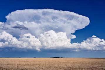
The vertical current can sometimes keep going up for a while. Storm tops display a variety of shapes. Here's one called an Anvil.
Thunderheads, or anvil clouds, are distinctive clouds that form in the upper parts of thunderstorms. Due to its flat, spreading shape, we call it an anvil (officially an incus).
If the current goes high enough the stratosphere acts as a "lid" or "cap," keeping the cloud from growing vertically. Instead, the cloud spreads horizontally, creating this anvil shape. The cloud then spreads in the downwind direction and can last for a while after the storm dissipates.
Anvil clouds are formed by dynamic processes within thunderstorms and interaction between the storm and the surrounding atmosphere. Often a sign of severe weather, it's a visually striking feature associated with mature or decaying thunderstorms.
So, we ascend a parcel symbolically by tracing the dry- or pseudo-adiabat upwards. Then check if it's warmer or cooler than the environmental air shown on the sounding (the bold line).
The two most important points in the start of weather convection currents are the LCL, basically the height at which condensation begins to occur as air rises, while the LFC is the point at which an air parcel becomes buoyant and can rise freely. Understanding cloud formation, atmospheric stability, and thunderstorms and convective activity is important for forecasters.
Go back from Weather Convection Currents to the Chasing Storms web page.
#33
Search this site for more information now.
Convection currents in the atmosphere: How do they produce storms?
Air mixing, weather convection currents, and possibly severe storms are caused by patterns of instability. Inversions and lapse rates and their roles.
Do you have concerns about air pollution in your area??
Perhaps modelling air pollution will provide the answers to your question.
That is what I do on a full-time basis. Find out if it is necessary for your project.
Have your Say...
on the StuffintheAir facebook page
Other topics listed in these guides:
The Stuff-in-the-Air Site Map
And,
Thank you to my research and writing assistants, ChatGPT and WordTune, as well as Wombo and others for the images.
OpenAI's large-scale language generation model (and others provided by Google and Meta), helped generate this text. As soon as draft language is generated, the author reviews, edits, and revises it to their own liking and is responsible for the content.


New! Comments
Do you like what you see here? Please let us know in the box below.