- Air Homepage
- Alberta Air Quality
- Air Quality Dispersion Modelling
- Air Quality in Canada
How to Forecast air quality in Canada's West: AERMOD vs. CALPUFF
What's the best air quality model to use for predicting air quality in Canada? The right dispersion model is key to navigating air quality in Western Canada, especially in British Columbia. Below is what each of the four provinces has to say about refined air quality models.
Can your air quality assessment stand up to regulator scrutiny in Canada's complex terrain? You can choose between the straightforward AERMOD and the advanced CALPUFF dispersion model without risking rejection - Air Quality Modeling in Western Canada: AERMOD vs. CALPUFF
 Models for forecasting air quality in rugged areas
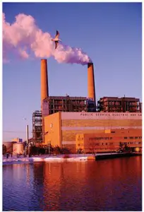
With its components for handling meteorological and terrain data, AERMOD is suitable for straightforward, steady-state pollutant dispersion over shorter distances and relatively flat countryside.
With its ancillary programs CALMET and CALPOST, CALPUFF is better suited for complex, even mountainous, terrain with intricate wind patterns, valleys and bends. CALPUFF's sophisticated approach includes factors like puff splitting, chemical transformations, and deposition processes, which provide regulatory assessments with detailed spatial variations.
AERMOD is good for distances considerably less than 50 km and for simpler scenarios, while CALPUFF's advanced modelling helps us get accurate air quality predictions for larger areas. In Western Canada's diverse landscapes, both models help us protect the environment and comply with regulations.
Who would find this interesting?
- Air quality regulators and policymakers: They need to make informed decisions about public health and environmental protection.
- Environmental Consultants and Scientists: They use these models to assess air quality, evaluate pollution impacts, and make mitigation recommendations.
- Companies that need to understand how to model and mitigate their environmental impact to comply with regulations.
- Researchers may be interested in the technical details and applications of these models.
- Public health officials who need to assess pollution's potential impact on human health for strategies to protect vulnerable people.
- Advocacy and community groups: They're interested in how air quality is assessed and managed so they can hold polluters accountable.
Why?
- Better chance of compliance with legal standards.
- Accurate pollution dispersion prediction, which is important for environmental planning.
- Model performance details help stakeholders make decisions about pollution control and mitigation.
- Protection of the environment: Knowing these models helps protect and improve air quality in Canada.
- In areas with sensitive receptors or high pollution levels, air quality assessments help us protect community health.
Modelling Air Quality in Canada - Western Provinces' Views...
There are a few things to consider when choosing between AERMOD and CALPUFF in British Columbia:
- CALPUFF works best in areas with complex wind and turbulence patterns over short distances or stagnation for a long time.
- For shorter transport distances or when only maximum concentrations are needed, AERMOD's straight-line trajectory might work. In complex terrain, like around bends and valleys, CALPUFF is more appropriate, provided representative meteorological data are available.
For Level 2 and 3 Assessments in BC, where complex flows are common and detailed spatial variations of concentration/deposition fields are required, CALPUFF is popular. It's a scientifically based regulatory tool for handling complex flow situations that's technically superior.
 Predicting if there will be air pollution in BC
The AERMOD system calculates air quality in Canada using regulatory plume modelling. It has three components: AERMOD (which calculates concentrations), AERMET (which prepares meteorological input), and AERMAP (which prepares terrain input).
AERMET converts meteorological data from suppliers like the National Weather Service or on-site measurements into AERMOD format. Surface characteristics like roughness length and albedo are crucial and can be specified manually or with AERSURFACE, which uses US Geological Survey data.
AERMAP processes terrain data for receptors and sources. BPIPPRM provides information about buildings that may cause downwash of plumes after they leave a nearby stack. The project may need other types of data in British Columbia that need further manipulation before preprocessing.
In industrial complexes, both single and multiple sources, AERMOD is often recommended. The software handles buildings with or without downwash, gas and particle depositions, constant or varying emissions, rural or urban areas, and distances up to 50 km.
AERMOD should be used, with default options set for elevated terrain, stack-tip downwash, calm winds, and missing data processing, as well as a 4-hour half-life for SO2 in urban settings. MODELOPT in the input file allows you to control these settings.
CALPUFF is a more sophisticated model for handling air quality dispersion. There are three main parts: CALMET for meteorological data, CALPUFF for concentration calculations, and CALPOST for output analysis.
To account for complex wind and turbulence patterns, terrain effects, and other meteorological phenomena, CALMET is able to process meteorological data from various sources. CALPUFF then simulates how pollutants disperse in the air. Factors like puff splitting, chemical transformations, wet and dry depositions, and gravitational settling are taken into account.
For complex scenarios like coastal areas or regions with a lot of varying terrain, CALPUFF is usually chosen to handle multiple sources, contaminants, and deposition processes. The latest version is recommended, and certain settings in the model need careful consideration based on the application.
CALPUFF modelling relies on quality assurance and quality control. To make sure the results are accurate and reliable, input data, model parameters, and output files are thoroughly checked. It's important to have expert judgment and experience when applying this model, especially, and interpreting results.
An alternate model might be considered if the recommended models don't work for a particular situation. Using relevant performance indicators like maximum hourly concentrations or spatial patterns, the selected alternative model should have demonstrated better performance in similar situations. Also, the alternate model should be publicly available.
Changing a model can, however, have unexpected results because of its complexity. Modifications must be justified, documented, and tested if needed. Modifications to CALPUFF should comply with the CALPUFF End-User License Agreement and include proper documentation.
In Alberta,
If a screening assessment was conducted and it says there might be air quality violations or if the area under consideration has environmental concerns (like a national park) or public concerns (like sensitive receptors), then more detailed assessments are needed using advanced or refined regulatory models. Sensitive receptors can include things like schools, hospitals, etc.
Refined models provide a more thorough analysis of the impacts of single or multiple sources. The regulatory refined models used for these assessments are described below.
 Assessment of air quality concerns in Alberta
The AERMOD model was developed by the United States' Environmental Protection Agency (EPA) in 2004. This model simulates pollutant dispersion from multiple sources in different atmospheric conditions. Under convective conditions, the model uses a bi-Gaussian probability density function for vertical distribution of pollutant concentrations. This provides a better prediction of air quality in Canada.
In convective conditions, AERMOD tracks plume mass entering elevated stable layers and plume lofting. It's recommended to use the default options provided by the EPA when running AERMOD, but some deviations are allowed. In order to deviate from these options, you have to meet advanced assessment requirements.
CALPUFF simulates how substances move and transform in the atmosphere under fluctuating meteorological conditions. Considering factors like wind patterns and terrain effects, it can handle complex scenarios with multiple layers and substances. For steady-state models, CALPUFF can use CALMET's detailed three-dimensional meteorological data matrix. Grid spacing should be about 1/10th of the size of the features being studied, like valleys, for a properly-resolved meteorological grid.
An appendix in the Alberta Air Quality Modelling Guideline outlines recommended deviations from the default model options provided by the developers. Deviations from these defaults are considered advanced assessments, requiring specific criteria to be considered.
A Director's approval is required before using an alternative air quality model. Depending on terrain, climate, emissions, or receptor sensitivity, you might need a different model.
Alternative models should be supported by observational studies, theoretical comparisons, or on-site data. It needs to meet acceptability criteria and outperform recommended models while remaining conservative. In performance evaluation, Alberta modellers and regulators check accuracy, correlation, visual presentation, precision, and bias.
They don't accept deprecated or proprietary models. In Table 1 of the Guideline, you'll find approved air quality models for different assessment levels and situations, along with their restrictions and requirements.
Saskatchewan Air Quality Assessments
...use advanced models like the EPA's AERMOD and CALPUFF as well. Based on regional meteorological data and input parameters like terrain and surface features, these models offer more detailed and realistic results. When multiple emission sources are involved or screening models predict compromised air quality in Canada, that is pollution levels above permissible levels, these refined models are used to explore the case in greater, more realistic, detail.
As part of the design of monitoring networks, refined models help identify potential pollution sources, analyze worst-case scenarios, and pinpoint areas of concern. Using conservative assumptions, initial assessments should show compliance with air quality standards.
Refined modelling can account for factors like variable emission rates or facility modifications. Concentrations that exceed provincial standards may require additional assessments to determine their extent and location.
The AERMOD model was developed by the EPA. It simulates pollution dispersion from various sources simultaneously when needed. Concentrations for different time periods are calculated assuming a straight-line, steady-state dispersion of pollutants.
AERMET processes meteorological data; AERMAP processes terrain data; and AERMOD calculates concentrations. AERMET generates meteorological files based on surface characteristics, while AERMAP provides elevations for receptors and sources. By using the Building Profile Input Program for Plume Rise Model Enhancements (BPIPPRM) algorithms, AERMOD can incorporate building downwash effects.
 Transport of pollutants over long distances in flatlands
AERMOD can model emissions from different types of sources and allows variable emission rates based on time of day. It's used for assessments within 50 km of emission sources, beyond which CALPUFF is recommended, especially when there's low wind speed, complex terrain, or secondary pollution. These conditions can negatively impact air quality in Canada.
Model output options include tabular results, plot files to be used for graphical representation, post files for time-varying trends, threshold violation files for assessing exceedances in a statistical manner, and daytime maximum files for specific pollutants. Combined effects of multiple sources can also be analyzed with source grouping.
CALPUFF simulates how pollutants disperse and change over time in the atmosphere. This system has three main components: CALMET, which creates detailed wind and temperature data based on terrain information; CALPUFF, which models how pollutants spread; and CALPOST, which processes the model's output.
You can use CALPUFF to predict air quality in Canada, wet and dry deposition, chemical transformation, visibility, fogging, and icing. It's great for complex terrain and calm winds, and it can simulate both short- and long-range pollutant transport. To ensure consistency and accuracy, the Ministry of Environment provides recommended settings for CALPUFF.
Everything from wind field options to chemical transformation algorithms is covered here. Unless there's a good reason to deviate, users should follow these recommendations.
You can also use other approved models specialized for specific tasks or conditions if AERMOD and CALPUFF aren't right for you. Appendix A of the Saskatchewan guideline and their respective user guides have details about these models and their data requirements. Using a specialized model should be justified, explaining why the recommended models don't work and showing why it's a better choice. The EPA must approve any model used for regulatory purposes.
Manitoba Conservation
If the facility is complex or if screening model assessments suggest potential issues with projected pollutant concentrations, Manitoba authorities recommend refined air dispersion modelling. Consult Manitoba Conservation before doing refined modeling to make sure all factors are taken into account.
For refined modelling, you'll need to consider normal plant operations and emissions, variations in emissions over time, peak operating conditions, and emissions during startup, shutdown, and upset periods.
Including plume rise, dispersion factors, and meteorological conditions, all model options must be documented. An explanation must be provided if default settings weren't used.
Calvin Consulting's Air Quality Expertise will make sure it is done right
Take a deep breath of fresh air. That's our passion at Calvin Consulting Group Ltd. Our air quality dispersion modelling helps businesses like yours breathe easier. For your firm, for the environment, for society.
Think of air pollution like campfire smoke. You might be able to predict simple situations, like flat, open fields. What about complex situations? On a windy day, imagine that campfire nestled in a valley. Here's where things get tricky.
Here's where Calvin Consulting comes in. We use advanced tools like AERMOD and CALPUFF to account for things like:
- What's the wind like in your area? Do you know if it's constant or unpredictable?
- What's the terrain like? Are there mountains or valleys around? Pollutants can move differently because of these things.
- How do nearby facilities contribute to pollution?
With over 30 years of experience, our meteorologists and modellers can handle anything. We've even trained government agencies on them!
What do we do to help?
- We collect data about your site, as well as prevailing weather patterns and surrounding geography.
- Depending on your situation, we'll use AERMOD or CALPUFF.
- The chosen model simulates how pollution would behave in your environment.
- Analyze the results: See if the pollution levels are okay.
- We give you (and the authorities) a clear, easy-to-understand report.
Calvin Consulting gives you peace of mind, not just answers. Get in touch with us today to discuss your air quality dispersion modelling needs!

Clean air is our Passion...Regulatory Compliance is our Business.
Recent Articles
-
the sun
May 17, 26 07:26 PM
 Cosmic Midlife Crisis: - Is the Sun Melting the Earth? Are you worried that the giant burning star in our sky is melting the Earth? Global warming isn't
 -
methane air pollution
May 16, 26 02:20 AM
 Methane is the secret smog maker - Gas from farm animals and garbage dumps can turn a blue sky into a brown soup? It turns out methane gas is linked to
 -
Global Warming Klan
May 15, 26 12:57 AM
 Planet Rescue: Real Action or Total Chaos? - Some people are so worried about the world that they come up with some pretty crazy ideas. Discover how kids

When it comes to understanding air quality in Western Canada, you might have to choose between AERMOD and CALPUFF.
AERMOD is good for straight-line dispersion over short distances, while CALPUFF is good for complicated terrain with intricate wind patterns. CALPUFF often outperforms in British Columbia, where topographies are varied and detailed spatial analysis is crucial.
For regulatory compliance and protecting the region's environment and public health, both models provide accurate pollutant concentration predictions under varying circumstances.
Do you have concerns about air pollution in your area??
Perhaps modelling air pollution will provide the answers to your question.
That is what I do on a full-time basis. Find out if it is necessary for your project.
Have your Say...
on the StuffintheAir facebook page
Other topics listed in these guides:
The Stuff-in-the-Air Site Map
And,
Thank you to my research and writing assistants, and the author remains responsible for the content.
Most Popular Pages on this Website:
Pictures of Global Warming
- See photos, cartoons, charts, graphs and a few surprises.
Clouds
- Don't know a cumulus from a stratus? Check here.
Causes of Global Warming
- It's not always obvious.
Calgary Alberta Weather
- Example of Canadian Goodness.
Thermometers
- Our favourite weather instrument.
- Home
- Contact Us
- Free E-zine Back Issues
- Privacy Policy
- Site Map - I'll help find something good.
By Barry Lough, P.Met., EP (Environmental Professional)
Text copyright © 2003-2024 Stuff in the Air.com
BACK TO TOP - Hit your 'Home' Key