- Air Homepage
- Upper Atmosphere
- Different Types of Clouds
Understanding how different types of clouds result from air motions
What's happening in the air to make different types of clouds? Could they affect you?
Clouds move across the sky in all kinds of shapes and sizes. When you look up at the clouds, you may feel connected to nature. Relax and unwind with it.

How Every Cloud Is Made: The Science of Lift - Did you know that a thunderstorm cloud is a ball rolling down a hill, and a flat layer of fog is a ball stuck in a bowl? Find out why you get clear skies, flat stratus layers, or towering cumulonimbus thunderstorms by understanding the physics of air stability.
Clouds are interesting because they are always changing and can have a magical or spiritual quality. They can make people feel a sense of awe and wonder, and have been symbols of spirituality for many cultures. Clouds can be a great source of inspiration for artists.
They can create beautiful art by painting the ever-changing colors, shapes, and patterns of clouds, and they can use clouds to add atmosphere and emotion to their artwork. Clouds can also represent freedom and adventure.
Clouds help keep our climate balanced by reflecting sunlight and heat to keep us cool, as well as trapping heat to keep us warm. They also provide us with rain and snow, which helps us grow food and stay hydrated.
Clouds can affect how much sunlight and pollution reach the Earth. This can change how plants grow and how much energy we can make from the sun. Because clouds involve a lot of physics, scientists study them to help them better understand how the Earth's climate and weather work. They look at how clouds form and interact with the atmosphere to help them make better predictions about the future.
This is because understanding cloud types is important for producing weather forecasts, air quality assessments, and climate studies
How different are these clouds?
Cirrus clouds are high-level clouds while stratus clouds are long, flat, and horizontal. Depending on their altitude, they can be classified as cirrus and alto for high and medium level, respectively. A cloud formation is called a nimbus when it produces precipitation.
Some different types of clouds are more specialized - they can only be found under certain atmospheric conditions or in a limited geographic area. The lenticular "lens-shaped" clouds shown in the montage above are an example. They are found near mountains.
Clouds that are puffy, pillowy, or piled high are the most interesting. When they produce rain, they are referred to as cumulus or cumulonimbus (producing thunderstorms); there is that "nimbus" again.
In order to get a more descriptive cloud name, meteorologists often combine two of these words. Alto-cumulus, for example, are puffy clouds at mid-levels. Take a look at the three examples above. By combining combinations like this, we can identify more than just four kinds of clouds.
How do clouds get their shapes? The properties of the air surrounding the clouds, known as the "air parcel" containing the clouds. There is quite a bit of science behind cloud formation.
Cloud Science - Cloud formation in the atmosphere is a complex process driven by physics, temperature, and moisture. They form when warm, moist air rises and cools, causing the moisture to condense into tiny droplets or ice crystals. The process is called condensation, and it's influenced by a lot of things like temperature lapse rate (the rate at which temperature decreases as you go higher in the air), moisture in the air, and particles that act as condensation nuclei.
For meteorologists and atmospheric scientists, tephigrams and skew-T diagrams are great tools for analyzing and understanding the atmosphere. Tephigrams are graphs that show the vertical temperature profile of the atmosphere in meteorology, thus they plot temperature against height in the atmosphere Can you deduce all the other parameters for an air parcel from pressure, temperature, and dew point? Yes. Based on these, meteorologists can figure out which curve on the thermodynamic graph to follow.
Clouds form based on altitude, temperature, and moisture conditions in the atmosphere. Low-level clouds, like stratus and cumulus, form near the ground, while high-level clouds, like cirrus and alto, form higher up. A precipitation cloud forms when moisture droplets or ice crystals are big enough to fall as rain, snow, or other types of precipitation. In the lee (downwind side) of mountains, lenticular clouds form when the wind is forced over the terrain and creates a standing wave pattern.
Warning: technical lingo ahead
Take a look at the drawing in this sample, right below the thunderstorm photo. It shows a portion of a skew-T, log-P chart.
 Dynamic weather and air-parcel motion
Both a Skew-T Log-P Chart and a tephigram show the change in temperature and moisture as you go higher up in the sky, and are used by meteorologists to understand forces that can change the weather. There is one set of lines and curves leaning upwards to the left called adiabats. On a weather chart, an adiabat shows how a pocket of air changes in temperature as it moves up or down without gaining or losing heat.
When the humidity of the air reaches 100%, the air parcel traces a curved line sloping upwards to the right called a moist adiabat if the humidity of that air has reached 100%, enough to produce cloud.
In the sample, it follows the line labelled "saturation adiabat". If it is not saturated it follows the dry adiabat, the straight line going up to the left. When the air is moving downwards, follow the curved line for moist air only if cloud droplets are present, telling us it’s a saturated parcel.
Let's look at an ideal situation. Don't worry about air mixing, also known as entrainment.
Then, carry out temperature comparisons described in detail on this page. Doing so will tell you if it is stable, unstable or neutral. How so?
Stability describes how air in the atmosphere wants to stay where it is or move up and down. Here's how it works:
- Imagine a ball in a bowl. When you push the ball a little, it rolls back to the bottom. When a pocket of air (like a balloon) is pushed up or down, it will come back to where it started. That is stability. In weather, it usually means calm weather and clear skies.
- Now imagine the ball is on top of a hill. Even a little push will make it roll down the hill. A pocket of air pushed up in an unstable atmosphere keeps rising. Here's when clouds can form and storms can happen.
- The ball will stay where you push it if it's on flat ground. Likewise, it's hard for the air to move up or down in a neutrally stable atmosphere.
Stability classifications and the different types of clouds that result from them
There's stable and there's "stable". Some atmospheric conditions are more stable than others. Stability can be divided into a few categories:
Absolutely Stable - The external forces on a displaced packet of air (one that's moved upwards or downwards) automatically try to bring it back to its original level. No matter how much moisture is in it. These conditions usually bring clear skies, fog, stratus or high cirrus clouds. More on this further below.
Absolutely Unstable - The displaced parcel keeps going faster and faster. No matter how wet or dry it is. This structural concept is theoretical and remains virtually nonexistent in reality, with short-lived exceptions occurring during conditions of external forcing (such as within storms). It sure would give different types of clouds if it were to actually occur and persist. We would get strong cumuliform clouds. Big deep piles.
 What causes Thunder and Lightning?
Conditionally Unstable - In this section we look at stability that varies with whether the air is dry or saturated. This is also called potential instability. Most of our clouds form under this condition.
Air moves around and creates clouds because of convection, which moves heat. It happens in liquids and gases, like water and air and works better in unstable conditions. Here's an example:
Convective Instability of the Second Kind (CISK) – helps explain how big storms form and get stronger. This is how it works:
- As you go higher in the sky, the temperature of the surrounding air gets cooler. Sometimes, this temperature doesn't drop as fast as it usually does. It's called a "less steep" lapse rate.
- There's a lot of water vapor inside a storm (like invisible steam). Heat is released when this vapor turns into liquid water (like raindrops). "Latent heat" is what we call it.
- Heat and moisture build up near the Earth's surface. It's like adding fuel to a fire. Heat and moisture can cause the air to rise.
- When the air rises, it cools and the water vapor condenses into clouds, releasing latent heat quite quickly. The extra heat makes the air rise even more, causing the storm to grow.
- It can lead to strong storms with heavy rain, strong winds, and lightning. These storms are powerful because of heat and moisture near the surface, along with unusual wind patterns.

Neutral -
This time, the air parcel stays the same temperature as the surrounding air. We don't see much cloud under these circumstances either, though its stability depends on water content, too.
What else are stability calculations used for? Pasquill-Gifford is a classification system devised by two scientists in the 1960s. Subdivisions of stability are assigned capital letters A through F, denoting varying amounts of lapse (and thus stability). They're still used in
air quality modeling
today.
Air quality is greatly affected by atmospheric stability. Why? Because
stable air
traps pollution and different types of clouds near the ground or even in elevated layers.

#34
Here's an interesting situation...turbulent air gets well mixed, go figure! In the mixed parcel, the environmental lapse rate becomes neutral. If unsaturated air moved up through, it wouldn't feel any forces from ambient air pushing it upwards or downwards, so we'd say it's neither stable nor unstable.
Since moist air is less stable than dry air, it will convect (move upwards) more easily. Clouds form because of this upward motion. Clouds are made of water droplets, so moist air has the water supply needed to produce them.
What about absolute instability?
A rare condition. How long do you think it'll last? Not long at all. There has to be a steady source of heat from below, like cold air moving over a warm lake, a forest fire or strong sunshine quickly warming the ground underneath.
We'll get auto-convection and even more different types of clouds with super-adiabatic lapses. Then we get turbulence, followed by a neutral lapse rate.
Cloud formation and suppression go hand-in hand. Just by looking at the clouds, a meteorologist can tell what the temperature and moisture structure in the air is like.
Do you like what you see here? If you have any comments, please let us know.
Recent Articles
-
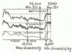
The Combination of Earth's Tilt and Eccentricity Cause Both Warming and Cooling
Apr 19, 26 09:27 PM
 The Great Cosmic Seesaw - You know how Earth wobbles around the Sun, deciding when it freezes over and heats up? We're about to find out how these giant
 -
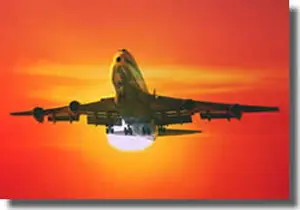
How much pollution does a plane put out
Apr 18, 26 02:51 PM
 The Mission to Measure Flight - Do you ever wonder if those white streaks behind a jet are just harmless clouds or pollution? Let's dig into the math of
 -
global warming increase temperature
Apr 18, 26 02:26 PM
 We're in a climate tug-of-war - You're standing in front of a giant control panel with a thousand dials that control the weather, oceans, and air. Right
Cloud Types | How Many Do You Know?
Different air motions produce different types of clouds. We see clouds formed by air moving up and down.
Do you have concerns about air pollution in your area??
Perhaps modelling air pollution will provide the answers to your question.
That is what I do on a full-time basis. Find out if it is necessary for your project.
Have your Say...
on the StuffintheAir facebook page
Other topics listed in these guides:
The Stuff-in-the-Air Site Map
And,
Thank you to my research and writing assistants, ChatGPT and WordTune, as well as Wombo and others for the images.
OpenAI's large-scale language generation model (and others provided by Google and Meta), helped generate this text. As soon as draft language is generated, the author reviews, edits, and revises it to their own liking and is responsible for the content.
You are here:
Most Popular Pages on this Website:
Pictures of Global Warming
- See photos, cartoons, charts, graphs and a few surprises.
Clouds
- Don't know a cumulus from a stratus? Check here.
Causes of Global Warming
- It's not always obvious.
Calgary Alberta Weather
- Example of Canadian Goodness.
Thermometers
- Our favourite weather instrument.
- Home
- Contact Us
- Free E-zine Back Issues
- Privacy Policy
- Site Map - I'll help find something good.
By Barry Lough, P.Met., EP (Environmental Professional)
Text copyright © 2003-2024 Stuff in the Air.com
BACK TO TOP - Hit your 'Home' Key
New! Comments
Do you like what you see here? Please let us know in the box below.