- Air Homepage
- Alberta Air Quality
- Air Quality Dispersion Modelling
- How to Determine Air Quality
Discover How to Determine Air Quality Using Proven Methods
The Western Canadian Modeller's Guide to Air Quality Dispersion - Have you ever wondered how scientists predict where industrial pollution will go across Canada's landscapes? Identify which powerful EPA-approved tools are mandatory for how to determine air quality in your region, from AERScreen to CALPuff.
Discover which air dispersion models work best for different situations, from flat plains to mountains. See how air dispersion models are used across Canadian provinces:
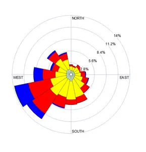
 Terrain models predict pollution
- British Columbia uses both steady-state and curved trajectory models to deal with its complex weather.
- Alberta has modellers start with simple models like AERSCREEN and progresses to more complex ones like AERMOD and CALPUFF.
- Saskatchewan uses default models for standard cases and adjusts for specific scenarios, while
- Manitoba recommends US EPA models like Screen3 and AERMOD.
To ensure precise air quality predictions, each province tailors its approach to its landscape and types of emissions sources. By estimating concentrations and adapting to different environmental challenges, the models help identify potential pollution impacts to help us with environmental policies.
Beginner's Guide to Air Quality Modeling
- This article introduces how to determine air quality levels using scientific air dispersion models.
- Find out which models work best in flat areas, mountains, and everything in between.
- Get the knowledge to ask the right questions about air quality assessments.
This text would be helpful for anyone interested in environmental health, policy, or regulatory compliance. Here, I'll help you learn how the four western Canadian provinces determine air quality using the most common models approved by the American EPA.
This shall give you a better understanding of regional approaches to environmental protection. Science, policy, and activists who care about public health and the environment will find this info handy.
How to Determine Air Quality with Models
British Columbia:
Within the Screening and Refined categories, the BC guideline sets out two general types of air dispersion models:
- The first types models calculate contaminant concentrations horizontally and vertically assuming uniform meteorological conditions. In complex flow situations, they don't consider curved plume trajectories or variable wind conditions. During winter, they can't handle low wind speeds, which are common in BC's valleys. Straight-line models can be either Screening or Refined in their levels of sophistication.
- Models with curved trajectory Gaussian puffs: These treat emissions as puffs over time and space as meteorological conditions change. Despite requiring more computing resources, they can track discrete contaminant amounts. They address accumulation during calm conditions, curved plume paths, and causality. Models like this fall into the Refined category.
The province of Alberta:
The air quality modeling approach starts with simple, conservative models, then moves on to more complex ones. According to Alberta Environment and Protected Areas (AEPA), there's one screening model (AERSCREEN) and two refined/advanced models (AERMOD/CALPUFF) available for easy access. With the exception of CALPUFF, these models are short-range, best at helping you with how to determine air quality within 50 km of the source.
AERSCREEN estimates air pollution levels from a single source, like a factory. It uses a model to predict pollution levels quickly and conservatively without needing detailed weather data. This tool is user-friendly and can handle different scenarios, like areas with hills or buildings that affect air flow.
It helps scientists and engineers see if more detailed studies are needed, saving them time and money. In order to use AERSCREEN, you'll need the latest versions of AERMOD and AERMAP. They are all free to obtain from the United States EPA by downloading from this page - https://www.epa.gov/scram/air-quality-dispersion-modeling-screening-models
 Modeling air quality using simple and complex terrain
By assuming a divided streamline of the plume, AERSCREEN and AERMOD split plumes. However in complex terrain, this method can lead to artificially high predicted ground-level concentrations. Hence, CALPUFF is better for projects in this type of terrain.
Elevations determine terrain complexity. In simple terrain, ground elevations nearby remain below 2/3 of plume height. And in complex terrain, elevations can be higher. For simple terrain determination, the Alberta government provides a spreadsheet. The logic for deciding whether complex terrain modeling is needed is shown in this figure on the right.
Hello from SK:
Like the other provinces, Saskatchewan's recommended air quality assessment models are:
- AERSCREEN: This is the screening model the Ministry of Environment (MOE) recommends.
- AERMOD: This is one of the recommended refined models for Saskatchewan.
- Calpuff: Another refined model recommended for specific cases.
 Source data and model recommendations
When modelling, you should generally stick with the default options provided by the SK regulatory guidelines and the model providers. There might be some cases where non-default options are needed. Any deviation from default options should be explained along with the reasons.
The more detailed sections and Appendix A of the Saskatchewan guideline provide more details about these recommended models.
Manitoba:
For assessing contaminants released into the air, various air dispersion models are available. There are different models for different sources, terrain situations, and operating conditions. For specific cases, like moist plumes near roads (which reduce visibility), you might need specialized modeling. The models and guidelines don't cover emergency situations like gas leaks.
In most cases, Manitoba Conservation recommends the latest versions of US EPA models, including Screening Models like Screen3 (at the time of this guideline's publication) and Refined Models like AERMOD and ISC3. Upon request, other models can be considered, as long as they can reasonably estimate pollutant concentrations.
Choosing a model should take into account factors like the type of emission source, averaging times for pollutants, terrain features, and land use nearby. It's important to clearly identify the chosen model along with its version and issue date, as well as any limitations.
We'll start with AERSCREEN
Taking a closer look at AERSCREEN, a screening model, we will now explore what each province says about it.
BC:
AERSCREEN is a simplified version of AERMOD used for screening air quality assessments. AERMOD is run with a matrix of meteorological conditions to estimate worst-case pollutant concentrations. For surface characteristics and terrain data, we use AERSURFACE and AERMAP preprocessors.
This model can be used for how to determine air quality, i.e., maximum concentrations for 1-hour, 3-hour, 8-hour, 24-hour, and annual averaging periods. It's specifically designed for a single source (point, capped stack, horizontal stack, flare, area, and volume) both in urban and rural areas.
AERSCREEN suggests adding predicted worst-case concentrations for each source or grouping closely spaced stacks together. It can't handle merged plumes, making AERMOD and CALPUFF better for detailed (Level 2 and 3) assessments.
AB:
Basic modelling assessments use screening methods like AERSCREEN to evaluate the impact of a single pollution source. Results from this screening model can be compared with other results as a reference point.
AERSCREEN is recommended by the Environmental Protection Agency. It works with AERMOD and generates worst-case meteorological conditions for your site. Various sources can be modelled, but only one at a time. If the total concentration stays below standards, further modelling may not be needed.
AERSCREEN calculates hourly pollutant concentrations and converts them to 3-hour, 8-hour, 24-hour, and annual averages. For averaging periods not explicitly provided by the model, you can use a formula to figure out the factor. Here's the formula:
 Calculate other averages from hourly concentration.
You multiply this calculated impact parameter by the maximum predicted 1-hour concentration for the averaging period you're interested in to get the relevant average concentration.
SK:
Screening models estimate worst-case one-hour concentrations for a single source without requiring on-site or real-time meteorological data. When potential concerns are predicted, more refined models are used. Additional modelling may not be needed if maximum predicted concentrations are significantly lower than the relevant standards or objectives.
 Consider terrain, buildings, and weather
AERSCREEN is the recommended screening model in Saskatchewan. It's a screening-level air quality model that estimates maximum concentrations without needing hourly meteorological data. It takes into account terrain and building information as well as meteorological conditions.
In AERSCREEN, you can calculate maximum concentrations for different averaging periods and model different types of sources. There are options for generating screening meteorology, error checking, and adjusting surface friction.
Source properties, building downwash data, terrain heights, temperatures, wind speeds, surface characteristics, receptor distances, urban/rural classifications, and fence line distances are all inputs. AERSCREEN, however, can only model one pollution source at a time.
AERSCREEN calculates concentrations on an hourly average, but more advanced models like AERMOD can do it on 3 hours, 8 hours, 24 hours, and annually. These averages are discrete, so they might miss elevated pollution levels between recording periods. Additionally, you can specify multiple averaging times in a single run.
It's important to convert maximum one-hour concentrations from AERSCREEN to maximum 24-hour or annual average concentrations when comparing results to 24-hour or annual criteria. AERSCREEN does this conversion automatically based on these ratios:
- Multiply the one-hour concentration by one for 3-hour averaging.
- You multiply the one-hour concentration by 0.9 for 8-hour averaging.
- Multiply the one-hour concentration by 0.6 for 24-hour averaging.
- Multiply the one-hour concentration by 0.1 for annual averaging.
MB:
Screening-level air dispersion models use simplified or advanced models with reduced meteorological data to estimate conservative, worst-case environmental pollutant concentrations from a facility. It's used to estimate worst-case concentrations, identify the impact area, and how to determine air quality modelling to use for greater detail when needed.
As part of screening assessments, maximum pollutant concentrations from plant operations and their impacts are considered, including start-up, shutdown, and upset conditions. The output includes predicted maximum concentrations, their locations, and stack parameters. Refined modeling may not be necessary if screening modelling shows no significant effects, but if concerns arise, more detailed modeling might be needed.
Calvin Consulting offers expert air quality solutions
Among our principal consultants, Calvin Consulting Group Ltd. has over 85 years of experience in air quality dispersion modelling, combined.
We site air quality monitoring stations and conduct VOC and radon monitoring for industries in Canada and abroad. We use advanced models like AERMOD and CALPUFF to deal with how to determine air quality.
We help facilities comply with environmental regulations and save money. We support better decision-making and environmental policies by predicting pollutant concentrations and providing feedback to you.
Regulatory authorities appreciate Calvin Consulting's comprehensive reports, complete with detailed analysis and visuals. With our proven expertise, you can protect your community and environment. Get in touch with us at [email address] to learn how we can help.
Calvin Consulting's specialized approach to air quality dispersion modelling reflects our concern for providing accurate air quality assessments and delivering reliable results. People who work in industrial settings, policy, or public health will find the insights we provide can help them do better than just meet regulatory standards.
Calvin Consulting provides accurate and reliable air quality assessments. Get in touch with us at

Calvin Consulting can help you master the air quality aspect of your project, and we tailor our services to suit your project's environmental and economic needs.
Clean air is our Passion...Regulatory Compliance is our Business.
Recent Articles
-
Air quality consultant who uncovered emissions, tension, and truth
Jun 01, 26 03:34 PM
 Why air quality consultants can make a difference - industrial expansion turned into an investigation into atmospheric science with cumulative emissions
 -
Lead Us From Darkness To Light From Global Warming To Global Cooling by Gopal Panicker
May 27, 26 12:41 AM
 A secret cooling prediction that flips the script - Planet Earth isn't warming up because of us, and a giant wave of natural cooling is coming. Get ready
 -
Environmental Social and Governance in Alberta
May 26, 26 11:04 PM
 Environmental Social and Governance why this province stands out in safety and monitoring, even as emissions, politics, and enforcement create risk.
Find out how to determine air quality using EPA-approved air dispersion models.
For detailed assessments, British Columbia uses straight-line and curved trajectory models, while Alberta prefers simple models initially and advances to complex ones later. Saskatchewan and Manitoba stick to recommended models, but allow exceptions.
To ensure accurate air quality predictions and public health protection, each region adapts its approach based on terrain, emission sources, and environmental conditions.
Do you have concerns about air pollution in your area??
Perhaps modelling air pollution will provide the answers to your question.
That is what I do on a full-time basis. Find out if it is necessary for your project.
Have your Say...
on the StuffintheAir facebook page
Other topics listed in these guides:
The Stuff-in-the-Air Site Map
And,
Thank you to my research and writing assistants, and the author remains responsible for the content.
Most Popular Pages on this Website:
Pictures of Global Warming
- See photos, cartoons, charts, graphs and a few surprises.
Clouds
- Don't know a cumulus from a stratus? Check here.
Causes of Global Warming
- It's not always obvious.
Calgary Alberta Weather
- Example of Canadian Goodness.
Thermometers
- Our favourite weather instrument.
- Home
- Contact Us
- Free E-zine Back Issues
- Privacy Policy
- Site Map - I'll help find something good.
By Barry Lough, P.Met., EP (Environmental Professional)
Text copyright © 2003-2024 Stuff in the Air.com
BACK TO TOP - Hit your 'Home' Key