- Air Homepage
- Air Quality Modelling Service
- Air Quality Dispersion Modelling
- What Is a Receptor
What Is a Receptor in Air Quality Modelling?
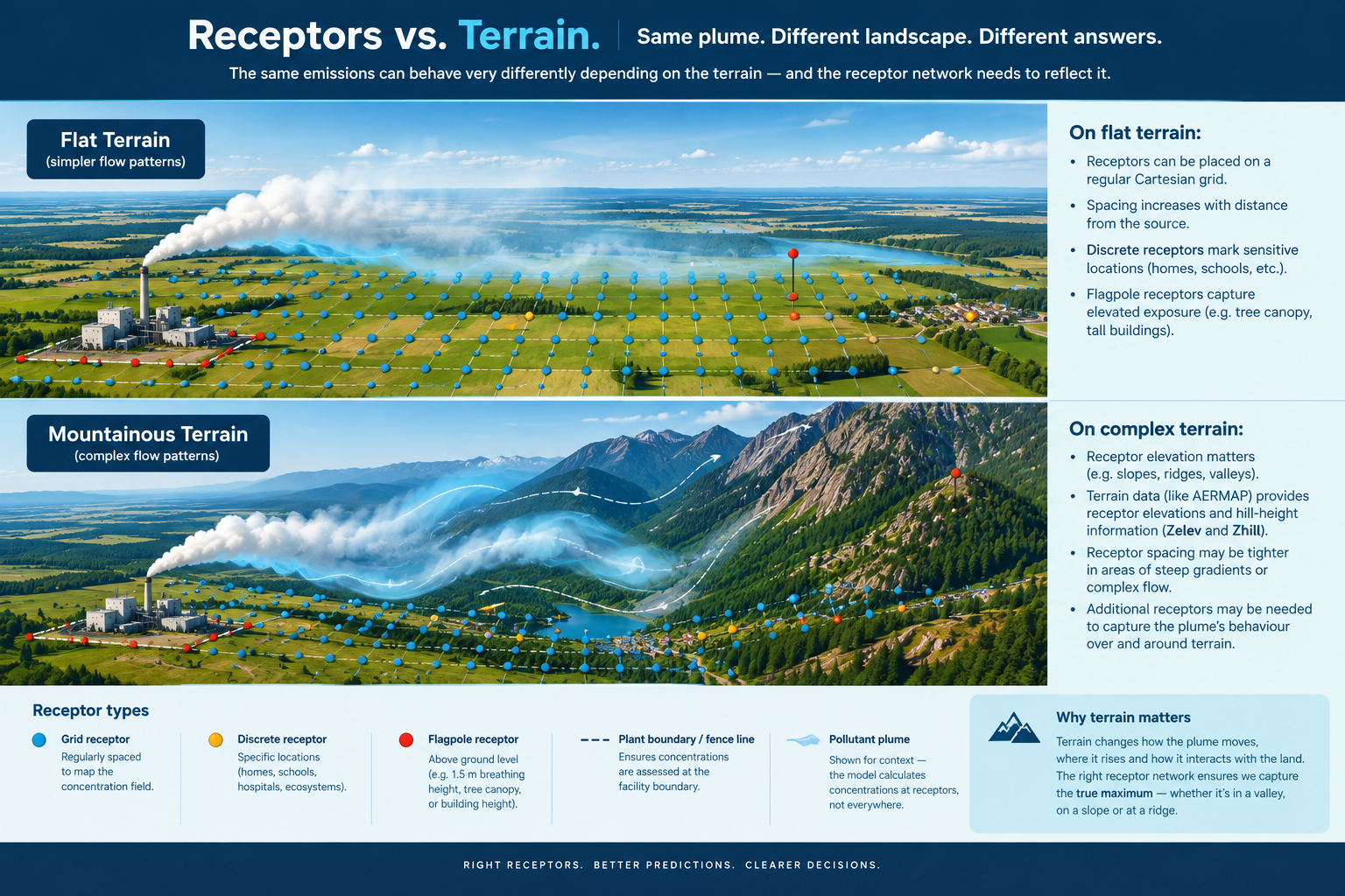
How receptor location, spacing and height affect predicted air quality...What is a receptor?
In air-quality dispersion modelling, a receptor is a location where the model is instructed to calculate a predicted pollutant concentration.
It sounds simple. It isn't. A receptor might be:
- a point on a regular grid;
- a location along a facility boundary;
- a residence, school or hospital;
- a point on a sensitive ecosystem;
- a point above the ground representing human breathing height;
- the top of a tree canopy; or
- a carefully selected location used to find a concentration maximum.
The model does not calculate concentrations everywhere. It calculates them at the locations we give it.
That makes receptor selection an important part of the science. A model can only find the maximum where you ask it to look.
This page explains what is a receptor, how receptor networks are designed, why spacing matters, how terrain and receptor height are handled and how experienced modellers decide when the standard grid is not enough.
What is a receptor, really?
Think of a dispersion model as a very large map with a lot of questions written on it.
Each receptor asks: What concentration would the model predict here?
 The expert placement of receptors leads to a better prediction of air dispersion.
A single receptor gives you one answer. A network of thousands of receptors gives you a picture of the concentration field around a facility.
That network might show a broad area of relatively low concentrations with a small region where concentrations are much higher. The challenge is to design the network so that it captures the important features of the plume without wasting modelling effort (e.g., where additional points tell us very little.)
This is why receptor placement matters. A poorly designed receptor network can miss a maximum. An unnecessarily dense network can create a huge amount of data without improving the assessment.
The objective is neither few receptors nor as many receptors as possible. It is: Enough receptors, in the right places, to answer the modelling question confidently.
Where do receptors go?
The most common arrangement in Alberta is a Cartesian grid (x, y, z). At Calvin, like most Alberta modellers, we use Cartesian grids rather than polar grids for our standard receptor networks.
A typical network uses different spacing at different distances from the source. That makes sense physically.
Close to an emission source, concentrations are more likely to change rapidly over short distances. Farther away, the concentration pattern usually becomes broader and smoother.
So we can use:
- tighter spacing where the concentration gradient is steep and
- wider spacing where the concentration field changes more gradually.
This is generally much more efficient than using the finest possible spacing everywhere.
The Calvin approach: start with a multi-density Cartesian grid
For many Alberta projects, we begin with a multi-density nested Cartesian grid.
The exact dimensions depend on the project and applicable guidance, but the principle is consistent: Start with an appropriately spaced network, then increase resolution where the results show that more detail is useful.
This is one of the reasons the receptor grid should be thought of as part of the modelling strategy rather than simply an input file.
- The initial grid answers: Where are the important areas?
- A refined grid answers: Exactly where is the important maximum?
That distinction is especially useful for students learning dispersion modelling because it explains why a model may be run more than once.
And yes...We still run it twice when the assessment benefits from it. The first run identifies the important area. The second run puts more receptors where the result needs to be resolved more precisely.
Why not use a very fine grid everywhere?
Because a receptor is not free. Every additional receptor creates another calculation and another output value.
 Grid-based modelling
A huge grid at 1-m spacing might sound wonderfully precise, but it could contain millions of receptors over a relatively modest area. That does not necessarily make the assessment better.
Instead, what is a receptor is best understood in terms of the question being asked.
If the purpose is to identify a broad regional concentration pattern, a relatively coarse network may be entirely appropriate.
If the question is: Where exactly is the maximum concentration around this small source?, then a much finer network may be justified.
The resolution should follow the problem.
When the standard grid isn't enough
Sometimes the initial grid doesn't give us enough confidence. For example, the predicted maximum may occur very close to the edge of the receptor network.
That creates an obvious question: Is that really the maximum or did the model simply run out of receptors?
In those situations, we may expand the receptor grid. We've done this on projects where the original default multi-density grid did not confidently capture the overall maximum.
The expanded network allows us to see whether:
- the concentration continues to increase outside the original grid;
- the maximum shifts;
- the original maximum remains stable; or
- the concentration field is adequately captured after all.
This is a good example of professional modelling judgment. The model shouldn't be allowed to decide that the edge of the grid is the edge of the impact.
Sometimes one metre really is justified
There are also situations where the problem is much tighter. If concentrations change very rapidly over a small area, even a conventional fine grid can miss a crucial maximum.
At Calvin, we have sometimes used very high-density receptor grids with spacing as small as 1 metre to investigate tight concentration gradients.
That might sound excessive until you understand the question. Suppose a source produces a steep concentration gradient across a small area.
With 50-metre spacing, the grid might identify the general area of the maximum. With one-metre spacing, we can determine much more precisely where the peak actually occurs.
The important point is not that one-metre spacing is 'better.' It's that: one-metre spacing can be appropriate when the concentration changes rapidly enough that coarser spacing cannot confidently locate the maximum.
What is a receptor when the maximum may be on a house?
Sometimes the area of interest is not simply the surrounding landscape. It is a particular property. For some assessments, we have placed small, high-density receptor grids over the footprint of houses to identify the maximum concentration on the property.
This can be useful when the modelling question is specifically about the exposure potential at a residence rather than simply the regional maximum. It is another example of a useful distinction:
- Grid receptors to Help us find the concentration pattern.
- Discrete receptors to Help us answer a question about a particular location.
The two work together.
Discrete receptors: ask a specific question
A discrete receptor is a specific location added to the model because it matters independently of the standard grid.
Examples include:
- a residence;
- a school;
- a hospital;
- a monitoring station;
- a facility boundary;
- a sensitive ecological location;
- a recreational area; or
- another location identified by the assessment.
The regular grid might tell us where the plume is strongest. A discrete receptor can tell us: What is the predicted concentration at this particular place?
This is especially useful when the location of interest does not fall conveniently on the regular grid.
Fence-line receptors
Facility boundaries can be important regulatory locations. At Calvin, we commonly supplement the regular grid with fine receptor spacing along facility fence lines or other relevant boundaries.
This matters because the regular grid may be too coarse to describe what happens immediately outside a facility.
A boundary receptor also answers a very specific question: What does the model predict at this part of the facility boundary?
The exact definition of the applicable boundary depends on the regulatory framework and circumstances, but the general modelling principle is simple: The receptor network needs to represent the places where the assessment actually matters.
What is a receptor above ground level?
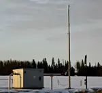
A receptor does not have to sit directly on the ground. A flagpole receptor is a receptor located at a specified height above the local terrain.
This can be important when the modelling question involves:
- human breathing height;
- elevated work areas;
- balconies or other elevated locations;
- treetop exposure; or
- other specific vertical locations.
AERMOD supports a receptor flagpole height, commonly represented by the Zflag value. Its terrain-related receptor inputs also include Zelev and Zhill.
 Receptor for the Canadian flagpole
Why receptor height can matter more than you might expect
Imagine a very short stack. The plume is close to the ground. A receptor at 0 metres and a receptor at 1.5 metres may sit in noticeably different parts of the plume.
In that situation, changing the receptor height by only 1.5 metres can substantially change the predicted concentration.
For a much taller stack, the same change may have little practical effect. So: The importance of receptor height depends on where the receptor sits relative to the plume.
This is one reason flagpole receptors should have a purpose rather than being added automatically.
Human breathing height
When a modelling assessment concerns potential human exposure, an elevated receptor can sometimes provide a more meaningful representation than a receptor exactly at ground level. A common example is approximately 1.5 metres above local ground level.
At Calvin, we have used this kind of flagpole receptor in assessments where the modelling question involves potential exposure or where the release characteristics make receptor height important.
For explosive-potential screening, where predicted methane concentrations are compared with the lower explosive limit (LEL), we have also used a flagpole receptor at the elevation where spark-generating equipment would actually operate, typically around 1.5 metres.
The important principle is: The receptor height should represent the physical question being asked.
What is a receptor for vegetation?
People aren't the only receptors. For vegetation assessments, elevated receptors can be used to represent the tree canopy or another biologically relevant height.
That can be useful because a contaminant does not necessarily interact with vegetation at ground level. If the assessment concerns potential effects on tall vegetation, a receptor at the canopy height may make more physical sense than one sitting at the soil surface.
 Receptors in farmland and natural areas
Again, the receptor isn't merely a dot. It represents an exposure location.
A special case: a vertical wall
One of the more unusual receptor networks I've used involved multiple flagpole receptors along the vertical face of a large residential building in Calgary.
Instead of asking only: What is the concentration at ground level?, the model was also used to investigate concentrations at multiple elevations along the face of the building.
This is a good illustration of how flexible receptor placement can be. A regular ground-level grid would not have answered that question nearly as directly.
The receptor network was designed around the physical situation.
What is a receptor in elevated terrain?
In hilly or mountainous terrain, receptor elevation becomes an important part of the modelling. A receptor has a horizontal location, but it also sits at a particular terrain elevation.
 Using digital elevation data to predict pollution.
AERMOD's terrain processing uses AERMAP to obtain terrain information and calculate receptor-related elevation and hill-height scaling information. Current AERMOD documentation identifies Zelev as the receptor elevation and Zhill as the corresponding hilltop elevation used by the elevated-terrain algorithms.
This is worth understanding because the two numbers answer different questions.
Zelev - The actual terrain elevation at the receptor. Think: How high above the reference datum is the ground where this receptor sits?
Zhill - The hill-height scaling information associated with that receptor. It helps AERMOD represent the relationship between the receptor and surrounding terrain when its elevated-terrain algorithms are applied. Think: What nearby terrain feature matters to the way the model sees this receptor?
AERMAP generates these terrain-related inputs from the digital elevation data used for the assessment.
Terrain makes receptor placement more interesting. In relatively uncomplicated terrain, receptor placement can be fairly straightforward.
In foothills or mountains, things become more complicated. A receptor may sit:
- on a valley floor;
- on a slope;
- on a ridge;
- on a plateau; or
- near a local terrain high point.
The same plume can interact very differently with those locations. That is why terrain data and receptor placement should be considered together.
A technically correct set of X and Y coordinates is not enough if the terrain associated with those points is poorly represented.
Current AERMOD guidance also cautions against using an artificially 'conservative' maximum nearby elevation in place of the actual receptor elevation; the receptor elevation should represent the best estimate of the actual terrain at that location.
What is a receptor when the terrain itself is important?
This is where a modeller has to think beyond the spreadsheet. Suppose a regular grid identifies a high concentration near a steep hillside.
The modeller should ask:
- Is that maximum physically plausible?
- Does the terrain representation make sense?
- Is the receptor actually on the slope shown by the map?
- Could a small change in receptor placement move it onto a substantially different elevation?
- Would another nearby receptor provide a more meaningful result?
That is more than just data processing...it is interpretation.
Polar or Cartesian?
There are two common ways of arranging receptors:
Cartesian - A rectangular grid based on X and Y coordinates.
Polar - Receptors are arranged around a source using distance and direction.
Both approaches exist in modern dispersion models. But in Alberta, Calvin's standard approach is Cartesian. We don't use polar grids simply because they are available.
For our typical industrial assessments, the Cartesian approach integrates well with our nested, multi-density grids, boundary receptors, refinement grids and discrete receptors.
This also gives us flexibility when a project needs additional receptors in an unusual location.
BC flare assessments: when the grid gets deliberately denser...Some assessments call for a much more specific receptor network.
For example, BC guidance for certain Level 2 flare assessments specifies a minimum 10-km modelling radius and, for a Cartesian grid, receptors no more than 100 metres apart for the first 4 km and wider spacing farther out; extreme complex terrain can warrant even finer treatment.
That is a useful reminder: Receptor spacing should follow the modelling problem and the applicable guidance.
A modeller working on a flare assessment shouldn't automatically substitute the standard grid used for an unrelated industrial facility.
The main lesson
A receptor is simply a place where the model calculates a concentration. But choosing that place is not simple. The best receptor network is one that reflects:
- the plume,
- the terrain,
- the people and ecosystems that matter,
- the facility boundary,
- the modelling objective,
- and the regulatory question.
That's why receptor placement is more than drawing a grid.
The model can calculate a concentration at any point you give it. The difficult part is deciding which points are worth asking about. And sometimes the answer is a conventional multi-density Cartesian grid.
Sometimes it is a handful of discrete receptors. Sometimes it is a second, much finer grid. Sometimes it is a 1-metre grid over a small area. Sometimes it is a row of 1.5-metre flagpole receptors along a building.
Good modelling judgment is knowing which one the problem requires.
Need help designing a receptor network?
Receptor placement can look straightforward until you have to defend why the grid is the size it is, why the maximum is where it is, or why an apparently insignificant change in receptor height changed the result.
That is where experience becomes useful.
Calvin Consulting Group Ltd. has more than 30 years of experience developing and reviewing industrial air-quality dispersion models across Western Canada. We routinely work with nested Cartesian grids, boundary receptors, sensitive receptors, terrain, flagpole receptors, high-density refinement grids and unusual receptor configurations.
More importantly, we start with the question the model needs to answer.
The objective isn't to create the biggest or most complicated receptor network. It's to create a network that gives you confidence that the important answer has actually been found.
If you are trying to decide how to construct a receptor grid, interpret an unexpected maximum, or determine whether your existing model has enough resolution, contact Calvin Consulting before spending time refining a network that may not answer the question you actually need answered.
Give us a shout:

We'll handle the complexities, so you can focus on growth.
Clean air is our Passion...Regulatory Compliance is our Business.
Common receptor-placement mistakes
Making the entire grid extremely dense - More receptors do not automatically mean a more accurate assessment.
Using coarse spacing everywhere - A coarse network can miss tight concentration gradients.
Forgetting discrete sensitive receptors - A school or residence can deserve specific attention even when it isn't conveniently located on the regular grid.
Assuming every receptor should be at ground level - Some questions require flagpole receptors.
Ignoring terrain - A receptor's elevation can matter in elevated-terrain modelling.
Using the highest nearby terrain as a conservative receptor elevation - That is not an appropriate substitute for the actual terrain elevation in AERMOD's elevated-terrain formulation.
Treating the edge of the grid as the end of the impact - If the maximum is near the boundary, investigate.
Assuming a single receptor grid can answer every question - Sometimes the right answer is a second, smaller, denser or vertically distributed network.
A practical receptor-placement checklist
Before finalizing an air-quality modelling assessment, check:
Grid
-Is the primary network Cartesian and appropriately sized?
-Is spacing appropriate to distance and expected concentration gradients?
-Does the grid cover the potentially impacted area?
Refinement
-Has the initial model run identified an area requiring finer resolution?
-Is the predicted maximum comfortably inside the network?
-Would additional receptors materially improve confidence?
Sensitive locations
-Have residences and other relevant sensitive receptors been identified?
-Are discrete receptors needed?
Height
-Should receptors be at ground level?
-Is a human breathing-height flagpole appropriate?
-Are elevated work areas or structures important?
-Is a tree canopy height relevant?
-Is a vertical receptor network needed?
Terrain
-Are receptor elevations accurate?
-Has AERMAP processed suitable terrain data?
-Does the Zhill information make sense for elevated-terrain modelling?
Boundary
-Are facility fence lines or other relevant boundaries adequately represented?
Special cases
-Is the source unusually low, directional, intermittent or close to a structure?
-Does the assessment have a specialized regulatory receptor requirement?
Recent Articles


-
Gas Flare Output SO2 – How to control it.
Oct 04, 26 06:37 PM
 What's the best way to handle temporary flaring and its output SO2? In Directive 60, the Alberta Energy Regulator (AER) gives guidance.
 -
Natural Gas Leak Detection: Does YOUR Facility Need it?
Sep 28, 26 08:40 AM
 It's important for industries, especially in the energy sector, to have a natural gas leak detection program. It's often required by law.
 -
Computers in Meteorology | How Would they Help You?
Sep 26, 26 09:40 PM
 Computers in meteorology help us keep track of atmospheric data and make predictions.


What is a receptor network supposed to accomplish?
A good receptor network should answer three questions:
- Where is the important impact? - The grid finds the concentration pattern.
- How large is the maximum? - Refinement helps locate and quantify it.
- What happens at the places we specifically care about? - Discrete and flagpole receptors answer those questions.
That's why a good receptor network often contains several different kinds of receptors working together.
- - -
What an experienced modeller checks
Before accepting a receptor network, I ask:
- Does it cover the area where the plume could matter?
- Is the spacing appropriate for the expected concentration gradient?
- Are important maxima comfortably inside the network?
- Could the maximum be hidden between receptors?
- Are sensitive locations represented?
- Does the facility boundary need additional receptors?
- Is a flagpole height appropriate?
- Does the receptor elevation make sense?
- Does the terrain representation make sense?
- Would a finer grid materially change the answer?
- Would an additional receptor tell us something useful?
That last question is important. We don't add receptors simply because we can.
Do you have concerns about air pollution in your area??
Perhaps modelling air pollution will provide the answers to your question.
That is what I do on a full-time basis. Find out if it is necessary for your project.
Have your Say...
on the StuffintheAir facebook page
Other topics listed in these guides:
The Stuff-in-the-Air Site Map
And,
Thank you to my research and writing assistants, and the author remains responsible for the content.
When should a receptor network be refined?
At Calvin, some common reasons include:
- A predicted maximum is close to the edge - The original grid may not have captured the overall maximum confidently.
- The concentration gradient is very steep - A coarse network may skip over the peak.
- A sensitive receptor is nearby - A residence, school, hospital or ecological receptor may warrant specific treatment.
- The facility boundary requires finer resolution - The standard grid may not adequately represent concentrations immediately outside the facility.
- Terrain is important - A ridge, slope or valley may require additional receptors.
- The release is very close to the ground - Short stacks and low-level sources can create tight concentration fields.
- The modelling question is unusually specific - A house, building face, treetop canopy or equipment location may require a custom receptor network.
Most Popular Pages on this Website:
Pictures of Global Warming
- See photos, cartoons, charts, graphs and a few surprises.
Clouds
- Don't know a cumulus from a stratus? Check here.
Causes of Global Warming
- It's not always obvious.
Calgary Alberta Weather
- Example of Canadian Goodness.
Thermometers
- Our favourite weather instrument.
- Home
- Contact Us
- Free E-zine Back Issues
- Privacy Policy
- Site Map - I'll help find something good.

By Barry Lough, P.Met., EP (Environmental Professional)
Text copyright © 2003-2026 Stuff in the Air.com
BACK TO TOP - Hit your 'Home' Key