- Air Homepage
- Weather Maps
- Gulf Jet Stream
Gulf Jet Stream and Atmospheric Jet Stream: Fascinating Similarities
Is it really that easy? Like jet streams in the air, a gulf jet stream flows in the water. That's it. A strong ocean current that flows from the Gulf of Mexico, along the coast of the United States, and out into the Atlantic Ocean for instance. The gulf jet stream transports heat and moisture in the ocean and affects marine life and weather patterns just like jet streams in the air.
Find more about meteorology.
Jet streams and weather maps might just be your thing. Jet streams are powerful, narrow air currents that affect the weather. You can get insight into weather patterns by studying weather maps so you can plan trips and activities based on this.
Earth's Flow is governed by Two Jet Streams...Did you know a fierce river of water and a massive air current have a lot in common? Learn how the Gulf Stream and the atmospheric jet stream are shaped by the same forces.
Here's a simple atmospheric diagram.

Weather and Climate are Shaped by Jet Streams
Large air masses are separated by the jet stream. The jet stream is an area of strong winds in the upper troposphere that moves air masses. Warm and cold air masses are transported by jet streams, which help regulate Earth's temperature. Global weather patterns are also affected by them.
Meteorologists look at jet stream analysis when preparing a weather forecast. The "big picture" in the atmosphere is shown. Jet streams are fast-moving, meandering air currents. Weather is affected by temperature and humidity. For accurate forecasting, you need to know where and how strong the jet stream is.
By acting as a giant rubber band, the jet stream maintains north pole temperatures and keeps them in their proper place.
Air masses are separated by jet streams. As the name implies, jet streams are high-altitude, fast-moving, narrow air currents that flow along boundaries separating air masses. There are large bodies of air with similar temperature and moisture characteristics, and they are separated by fronts, which are the boundaries where two air masses meet.
Temperature and pressure differences between polar and tropical regions of the Earth cause jet streams, which can affect weather patterns and aviation. This relationship can cause turbulence and changes in wind direction when the jet stream flows along a front, and it can also affect weather systems' movement.
Global winds and the Gulf jet stream.
These theoretical winds behave like jet streams in the most crude sense.
Geostrophic wind - It's just a theoretical upper level wind. Predicting winds close to the ground isn't very accurate, but it's pretty good higher up in altitude. There's a lot going on near the ground that screws things up...
1) Friction - You feel wind. That's friction caused by air rushing by. Wind transfers momentum to you, so you feel the push.
Trees and mountains can change the speed and direction of the wind. As a gulf jet stream approaches an island, it changes course.
By the way, can you feel the wind in a hot air balloon? I've never been on one, so I don't know. There's very little friction between the balloon and the wind, even on a windy day, because it moves roughly the same speed and direction as the wind.

2) Flux - What's that? Heat exchange in the air. The transfer of heat or moisture from the ground or lake to the air. When it rains, it's the other way around. Heat transfers change the stability of the atmosphere and change the wind.
Stability is like balancing a rock on top of a pencil. It falls because of instability. In fact, water vapor has more heat energy than hot air. It makes things even more unstable.
3) Other distortions - Due to the earth's curvature, rotation and nearby pressure changes, atmospheric calculations are hard. Correction factors and terms have to be added to the equations.
A gulf jet stream or any other moving object can be changed by extra forces. For example, meteorologists talk about the Coriolis Force.
Here's some background on the physics of rotating fluids. If you need one that explains rotation's basic principles, including the Coriolis force, conservation of angular momentum, and vortices...it also discusses how rotating fluids are used in weather systems and ocean currents. See this article.
Oceanographers can figure out if the Gulf jet stream has similar problems.
Gradient wind - introduces another force into the equation, the Centripetal force. It's the opposite force of centrifugal force. Centripetal force keeps an object in a circular path. The object's inertia, or tendency to resist change, causes this force to be directed towards the center.
We created the geostrophic wind above by balancing the pressure gradient force, which pushes air from high pressure to low pressure, against the Coriolis force, which corrects for the earth's rotation.
Gradient wind adds centripetal force. It depends on how the pressure systems are oriented. Due to this balance, high-pressure systems have less wind than low-pressure systems.
You'll get different values depending on your latitude. We can get small low pressure areas, and even tornadoes, which spin in the opposite direction if the forces here are unbalanced.
There's more to meteorology than this gulf jet stream analogy suggests, but these fundamental forces are examined in detail and combined with additional forces to create thermal wind. I think this deserves its own article.
Jet streams and air masses are important aspects of atmospheric science and meteorology. Go Back from this Gulf Jet Stream page to the
Forecast Map Weather webpage now.

#20
Search this site for more information now.
Recent Articles
-
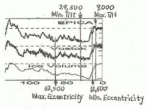
The Combination of Earth's Tilt and Eccentricity Cause Both Warming and Cooling
Apr 19, 26 09:27 PM
 The Great Cosmic Seesaw - You know how Earth wobbles around the Sun, deciding when it freezes over and heats up? We're about to find out how these giant
 -
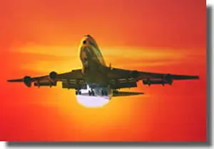
How much pollution does a plane put out
Apr 18, 26 02:51 PM
 The Mission to Measure Flight - Do you ever wonder if those white streaks behind a jet are just harmless clouds or pollution? Let's dig into the math of
 -
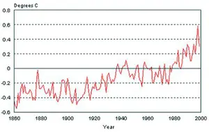
global warming increase temperature
Apr 18, 26 02:26 PM
 We're in a climate tug-of-war - You're standing in front of a giant control panel with a thousand dials that control the weather, oceans, and air. Right
Find the Gulf Jet Stream in the air
Similarly to a gulf jet stream, an atmospheric jet stream indicates the location of the fastest air movement.
Do you have concerns about air pollution in your area??
Perhaps modelling air pollution will provide the answers to your question.
That is what I do on a full-time basis. Find out if it is necessary for your project.
Have your Say...
on the StuffintheAir facebook page
Other topics listed in these guides:
The Stuff-in-the-Air Site Map
And,
Thank you to my research and writing assistants, ChatGPT and WordTune, as well as Wombo and others for the images.
OpenAI's large-scale language generation model (and others provided by Google and Meta), helped generate this text. As soon as draft language is generated, the author reviews, edits, and revises it to their own liking and is responsible for the content.
By Barry Lough, P.Met., EP (Environmental Professional)
Text copyright © 2003-2024 Stuff in the Air.com
BACK TO TOP - Hit your 'Home' Key
New! Comments
Do you like what you see here? Please let us know in the box below.