- Air Homepage
- Weather Radar
- National Weather Center
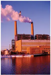
The National Weather Center
In tornado alley lies the National Weather Center research facility. An area with frequent mesoscale weather events would be perfect for this kind of storm research facility.
Search for more about weather.
Inside the National Weather Center: Tornado Alley's Guardians ⚡Could the world's most dangerous storms no longer surprise us, thanks to a research hub built in Tornado Alley? I'll show you how Doppler radar and expert knowledge are being used to predict and warn about life-threatening mesoscale weather with unprecedented accuracy at the National Weather Center, so you don't have to worry about the next big storm.

Is there anywhere else in the world where tornado research is done? This center is a collaboration between the National Oceanic and Atmospheric Administration (NOAA), the University of Oklahoma, and the state of Oklahoma.
There's no better place to innovate and collaborate than the National Weather Center. With cutting-edge technology and specialized knowledge, the NWC provides critical weather forecasts and warnings. In addition to severe weather, they provide valuable data for agriculture, aviation, and renewable energy.
In order to be better prepared for weather events, the NWC understands and predicts mesoscale and microscale phenomena. In addition to advancing atmospheric science, this facility protects communities and enhances resilience. Our everyday lives and future preparedness are impacted by the NWC's work.
Why was it created?
- The NWC provides weather forecasts and warnings for severe weather events, like tornadoes, hurricanes, and flash floods. Americans can protect themselves, their families, and their property from severe weather by receiving accurate and timely information from the NWC.
- The NWC provides weather information and forecasts to the aviation industry. Air traffic controllers and pilots rely on accurate and up-to-date weather data to make decisions about flight routes, takeoffs, and landings to ensure safe and efficient air travel.
- For planting, harvesting, and managing their crops and livestock, farmers and ranchers rely on accurate weather forecasts and climate data. Using the NWC, farmers can make informed decisions about their operations based on current and future weather conditions.
- Wind and solar power production can be affected by weather conditions, especially for renewable energy sources. Weather forecasts are provided by the NWC
The focus is on mesoscale weather. There could be high levels of precipitation, wind, or other weather patterns. A research facility must also have access to equipment, like radar, to observe mesoscale weather patterns.
Thunderstorms, tornadoes, hurricanes, and the like fall into the category of events under examination here. In terms of size, they're about a mile across to (maybe) a hundred.
Observation and prediction are the Center's main activities. The mesoscale and other smaller scales are also important to them. Short-term weather patterns, like storms, heat bursts, and other smaller events, are predicted by them. By understanding these scales, we can prepare for the immediate effects of weather.
While the larger-scale weather patterns are important for general forecasting, the mesoscale and other smaller weather scales provide us with more localized information that can help us to make more accurate predictions about short-term weather events, like thunderstorms or heavy rain.
Basically, how storms of this sort affect both big synoptic systems (spanning a state or two) and tiny microclimates (like parking lots).

A bit about scales: Microscale meteorology and mesoscale meteorology focus on different scales of atmospheric phenomena. The term mesoscale meteorology refers to weather events that happen on a scale of tens to hundreds of kilometers. To forecast these events, mesoscale meteorologists use numerical weather models, satellite and radar data, and other observations.
Measuring Micro- and Mesoscale Weather
Microscale meteorology, on the other hand, deals with atmospheric phenomena on a much smaller scale. Turbulence, wind gusts, and local temperature variations are examples of microscale weather phenomena. Microscale meteorologists use field experiments and computer models to understand and predict these phenomena.
Radar is the fundamental tool meteorologists use to identify and track medium-sized storms. You can find heavy precipitation, distinguish its type (rain, hail, snow, etc.) and pinpoint its direction. The Dopplar radar can also help predict tornadoes by determining wind directions and vorticity (patterns of rotation).
We've been told the center uses radar output to feed its physical mesoscale models. Data is used to set initial and/or boundary conditions, among other things.
They're good at this. Research and prediction of storms, where specialized knowledge is accumulated and refined. Then they use existing infrastructure to distribute their findings.
What is the purpose of the National Weather Center's actions?
According to the Center's website, it's good for:
- Knowing the causes and effects of climate change - NWC does research and analysis on climate change to better understand its causes and effects. This involves gathering data from various sources, like satellite observations, ground-based measurements, and computer models. Additionally, the NWC does outreach and education about climate change.

- establishing a network of storm information through their observing system - The NWC operates a network of weather radars, satellites, and surface weather stations to get storm information. Real-time weather data are collected by this observing system, which is used to develop forecasts and warnings.
- Researching and development to improve other NOAA weather radar images - NWC also develops new technologies to improve weather radar images. This includes developing new algorithms to detect and track severe weather, as well as new hardware to improve radar data.
- Providing portable radar units for emergencies - Finally, the NWC has portable radar units for emergencies. Portable units can be deployed quickly to areas hit by severe weather, providing valuable data to emergency responders. In an emergency, this helps improve situational awareness.
Contact them at...
National Weather Center (NWC)
University of Oklahoma
100 East Boyd St.
SEC Suite 710
Norman OK 73019
Phone (405) 325-3101
E-mail: nwc(at)ou.edu
As a summary, mesoscale meteorology focuses on large-scale weather phenomena, while microscale meteorology focuses on small-scale atmospheric processes. Understanding and predicting weather events require both, which is what the National weather center works to achieve.
Go back from National Weather Center to the Radar Real Time Weather webpage or to the Stuff in the Air homepage.
Search this site for more information now.
Recent Articles
-
the sun
May 17, 26 07:26 PM
 Cosmic Midlife Crisis: - Is the Sun Melting the Earth? Are you worried that the giant burning star in our sky is melting the Earth? Global warming isn't
 -
methane air pollution
May 16, 26 02:20 AM
 Methane is the secret smog maker - Gas from farm animals and garbage dumps can turn a blue sky into a brown soup? It turns out methane gas is linked to
 -
Global Warming Klan
May 15, 26 12:57 AM
 Planet Rescue: Real Action or Total Chaos? - Some people are so worried about the world that they come up with some pretty crazy ideas. Discover how kids

Are you familiar with the term "mesoscale" as defined by the National Weather Center?
Local and small area weather systems are the specialty of the National Weather Center. Someday, perhaps we will be able to predict tornadoes with precision.
Do you have concerns about air pollution in your area??
Perhaps modelling air pollution will provide the answers to your question.
That is what I do on a full-time basis. Find out if it is necessary for your project.
Have your Say...
on the StuffintheAir facebook page
Other topics listed in these guides:
The Stuff-in-the-Air Site Map
And,
Thank you to my research and writing assistants, and the author remains responsible for the content.
By Barry Lough, P.Met., EP (Environmental Professional)
Text copyright © 2003-2024 Stuff in the Air.com
BACK TO TOP - Hit your 'Home' Key