air pollution dispersion modeling
by Elahm
(Tehan,Iran)


USEPA
Learn how to model air quality with AERMOD and CALPUFF!
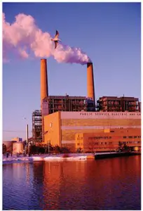
Elahm Asks: - I am an Environmental Engineer and I am very interested in modeling the Air Pollution (NOx, SOx, CO,...) which is caused by the fossil fuel power plants. I know that there are many softewares like disper and screen but they are not free to download. I would be so appreciative if you provide me any information for the air pollution modelling and guide me how I can find appropriate softewares which are free to download.
Thanks,
Elham
Barry's Response
- Here's a free download: good air quality models. What?There are several regulatory models available from the US Environmental Protection Agency. Take a look at the list and their download addresses below.
Check out the lists of models for different uses. Honestly, I don't know what most of them do, but I'm most familiar with CALPUFF, RTDM, ISC-PRIME (under alternate models), and SCREEN3. You can also get BPIP for free here if you're an industrial modeler.
Most of them come with manuals, executables, and source code. It's a playland for scientists.
I've provided a few explanations for how some of these models differ: CALPUFF, AERMOD & ISC
More on these computer programs below.
search this site for more information now.
The models and accessories
AERMOD
AERMOD predicts how pollutants disperse in the atmosphere using advanced air quality dispersion models. To estimate pollution concentrations, it takes weather, terrain, and emissions sources into account. For industries, urban areas, and more, AERMOD helps assess potential environmental impacts. Get the package here https://www.epa.gov/scram/air-quality-dispersion-modeling-preferred-and-recommended-models#aermod
You can also download a simplified version called AERSCREEN if you choose. Based on AERMOD, AERSCREEN is the recommended screening model. With this model, you can estimate "worst-case" 1-hour concentrations for a single source, without having to purchase hourly meteorological data, and you can estimate worst-case 3-hour, 8-hour, 24-hour, and annual concentrations, too. Based on a fully developed set of meteorological and terrain data, AERSCREEN should produce concentration estimates equal to or greater than those produced by AERMOD, but the degree of conservatism will vary. Get AERSCREEN here: https://www.epa.gov/scram/air-quality-dispersion-modeling-screening-models
It needs meteorological data to work. If you can get government or other formal data, you can process it with AERMET for AERMOD. AERMET estimates the meteorological parameters needed for air pollution dispersion modeling. For AERMOD simulations, it refines surface-layer meteorological data, taking into account terrain and land use. AERMET improves air quality predictions by enhancing the representation of atmospheric conditions, making it one of the best tools for assessing pollution's impact on the environment.
You can model flat terrain, like Saskatchewan or the ocean. When you need to include hills and whatnot, AERMAP is a modeling tool used in air quality assessments to create terrain elevation data for dispersion models like AERMOD. Digital elevation data and land use information are processed to generate terrain height and roughness parameters. As a result of incorporating local geographic features, AERMAP helps refine air pollution dispersion modeling predictions, improving air quality assessment and pollutant dispersion assessment. In environmental studies and regulatory compliance evaluations, it's crucial for simulating the complex interactions between emissions and local atmospheric conditions.
EPA also provides a free program to parameterize obstruction data for emissions from elevated stacks if they're among buildings causing turbulence on the site. In air quality modeling, the Building Profile Input Program (BPIP) is used. Here, you input parameters like building dimensions, materials, and emissions sources to create building profiles. For modeling how pollutants disperse around and inside buildings, these profiles are crucial. BPIP helps simulate the interactions between buildings and air pollutants, making it easier to understand indoor air quality. With this program, data entry is streamlined, allowing for accurate representation of building characteristics, which is crucial for comprehensive air quality assessments. Get BPIP here: https://www.epa.gov/scram/air-quality-dispersion-modeling-related-model-support-programs#bpip
BPIP output can be used in several of these air quality models.
ISC
Air pollution dispersion from industrial sources can be assessed with the ISC (Industrial Source Complex) air model. ISC3 is a steady-state Gaussian plume model that can assess pollutant concentrations from a variety of industrial sources. It can account for settling and dry deposition of particles; downwash; point, area, line, and volume sources; plume rise as a function of downwind distance; and limited terrain adjustment. The ISC3 operates both long- and short-term. For input into the model, ISC3 also uses the Emissions Modeling System for Hazardous Pollutants (EMS-HAP). Get ISC3 here https://www.epa.gov/scram/air-quality-dispersion-modeling-alternative-models#isc3
Screen3
This is the one I normally recommend for beginners It's easiest to use and does not require you to go find meteorological data. Screen3 is a single source Gaussian plume model that shows maximum ground-level concentrations for point, area, flare, and volume sources, as well as inversion break-up and shoreline fumigation concentrations. Screen3 is a screening version of ISC3. Get Screen3 here: https://www.epa.gov/scram/air-quality-dispersion-modeling-screening-models
RTDM
EPA's Rough Terrain Diffusion Model (RTDM) assesses air quality impacts in complex terrain. It takes elevation changes and varying atmospheric conditions into account when analyzing pollutant dispersion over rugged landscapes such as mountains. In challenging geographic areas, RTDM helps evaluate the effects of emissions from urban and industrial sources. It helps us develop effective strategies to manage and improve air quality in regions with diverse topographies by considering unique terrain characteristics. Get RTDM here: https://www.epa.gov/scram/air-quality-dispersion-modeling-screening-models#rtdm
CALPUFF
CALPUFF is a multi-layer, multi-species non-steady-state puff dispersion model that simulates pollution transport, transformation, and removal under time- and space-varying meteorological conditions. CALPUFF works on scales from tens to hundreds of kilometers. Subgrid scale effects (like terrain impingement) and longer range effects (like pollutant removal due to wet scavenging and dry deposition, chemical transformation, and visibility effects of particulate matter concentrations) are included. Get CALPUFF here: https://www.epa.gov/scram/air-quality-dispersion-modeling-alternative-models#calpuff
A supplementary program called CALMET processes and formats the meteorological data used for CALPUFF. CALMET (CALifornia METeorology) generates accurate meteorological data for these more advanced air quality simulations. It assimilates various meteorological measurements and observations to create high-resolution meteorological fields for dispersion models. Air quality predictions are more accurate thanks to CALMET, which improves the representation of local wind patterns, temperature, and other meteorological parameters. Using this model, we can better understand the relationships between meteorology and air pollution, helping us make better decisions and develop better policies to manage and improve air quality. Finally...
A comparison of AERMOD and CALPUFF,
the two most commonly used models lately.AERMOD steady state Gaussian plume model:
- It's known for accuracy (produces accurate results for short-range dispersion (up to 50 km)), EPA approval (U.S. EPA's preferred model for most regulatory applications) and simplicity (easy to set up).
- Range Limitation Not suitable for long-range transport (more than 50 km), and Meteorological Assumptions (Assumes uniform meteorological conditions, which may not be accurate).
- Applications like Industrial Emissions (evaluating emissions from factories and power plants) and Urban Air Quality (evaluating pollution in urban areas where sources are close) are ideal.
CALPUFF is a lagrangian puff model:
- Calpuff's strengths include Flexibility: Handles complex meteorological conditions, Range: Long-range transport (up to 200 km), and Detailed Analysis: Time-variant meteorological conditions are taken into account.
- However, regulatory approval is case-by-case. It's more complicated to set up and run, and you need detailed meteorological data.
- You can use it for Regional Air Quality: Assessing pollution over large areas with varying terrain, and for Long-Range Transport: Studying pollutants over long distances.
The discussion continues...
Comments for air pollution dispersion modeling
|
||
|
||
|
||
|
||
|
Click here to add your own comments Join in and write your own page! It's easy to do. How? Simply click here to return to Hi-Tech Idea. |
Recent Articles
-
methane air pollution
May 16, 26 02:20 AM
 Methane is the secret smog maker - Gas from farm animals and garbage dumps can turn a blue sky into a brown soup? It turns out methane gas is linked to
 -
Global Warming Klan
May 15, 26 12:57 AM
 Planet Rescue: Real Action or Total Chaos? - Some people are so worried about the world that they come up with some pretty crazy ideas. Discover how kids
 -
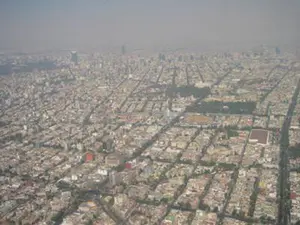
What causes pollution in the outside?
May 12, 26 12:44 AM
 The Hidden World of Pollution - Does the air you breathe have anything to do with a distant volcano or a dusty farm field? There's more to the gray haze
Do you have concerns about air pollution in your area??
Perhaps modelling air pollution will provide the answers to your question.
That is what I do on a full-time basis. Find out if it is necessary for your project.
Have your Say...
on the StuffintheAir facebook page
Other topics listed in these guides:
The Stuff-in-the-Air Site Map
And,
Thank you to my research and writing assistants, ChatGPT and WordTune, as well as Wombo and others for the images.
OpenAI's large-scale language generation model (and others provided by Google and Meta), helped generate this text. As soon as draft language is generated, the author reviews, edits, and revises it to their own liking and is responsible for the content.
Most Popular Pages on this Website:
Pictures of Global Warming
- See photos, cartoons, charts, graphs and a few surprises.
Clouds
- Don't know a cumulus from a stratus? Check here.
Causes of Global Warming
- It's not always obvious.
Calgary Alberta Weather
- Example of Canadian Goodness.
Thermometers
- Our favourite weather instrument.
- Home
- Contact Us
- Free E-zine Back Issues
- Privacy Policy
- Site Map - I'll help find something good.
By Barry Lough, P.Met., EP (Environmental Professional)
Text copyright © 2003-2024 Stuff in the Air.com
BACK TO TOP - Hit your 'Home' Key