- Air Homepage
- Radar
See Radar Real Time Weather for Immediate Forecasts
Well, yes and no. You can see real time weather radar real time weather information on the screen with a good radar, like this Canadian example or the US National Oceanic and Atmospheric Administration's weather radar.

The Radar That Sees Precipitation in Motion - Have you ever watched a storm move across a radar screen, knowing exactly when it's about to rain? Find out how RADAR technology works, from its military origins to the powerful Doppler systems that track everything from raindrops to rogue insects!
But it's not forecast info. A series of recent weather observations...very recent weather...is used to produce very short-term forecasts and emergency broadcasts using the imagery that results.
Watching the precipitation move across the map is mesmerizing. Seeing the intensity of each storm lets you know when it's coming. Plus, you can stay up to date on the weather.
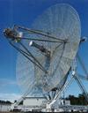
Radar site equipment sends data to computer weather stations. With the right analog to digital conversion software, specially coded algorithms and sequencing software, we can get an animated radar display that weather forecasters, broadcasters, and technicians use to show live weather radar.
Let's take a look at some of the science and technology behind radar US weather professionals and Canadian meteorologists use. Radar is an evolving technology, so relevant information can change.
The details are below...What do you think about this?
Greatest Weather Forecasts
Know a better place for forecasts? Really cool graphics or outstanding weather information?
All weather people like to find new places for unusual data, and here's your chance to help. Feel free to comment; that would be much appreciated. Thank you.
P.S. This is NOT the Weather Network.
What have the other people said about weather?
Scan here to see contributions from previous visitors to this page...
Real Time Radar ! 
If you want to see real time weather reports go down to the Tampa Fl. area. They show up to the minute imageing that shows rotation of tornados coming …
My ideas about radar
Weather radar forecasting on sites such as weather.com and accuweather.com give me up-to-date information about what to expect when I step out the door …
Applications of RADAR
RADAR is basically a device which can measure the distance between two objects and also used for weather forecasts. The principle involved in RADAR is …
Try R.A.P.
Pretty good little article, though it's probably important to point out that most radar returns especially from NOAA are only about 5 minutes behind the …
Radar 
Radar is always interesting to look at. It is neat to look at when storms are brewing. A good place for forecast would be www.theweathernetwork.com. …
radar signals
How do you find distant objects in the dark? use Radar, short for radio detection and ranging.
The Radar sends out a wave that bounces off the target …
Keep up with the latest. Publishers update their knowledge about radar real time weather periodically. To stay up to date, they subscribe to journals and periodicals. Back issues of my articles about general weather topics are still available here, though new ones are not being made anymore.
Clever Acronyms
Instead of saying RAdio Detection And Ranging every time, we shorten it to RADAR. It's become a powerful forecast tool for mesoscale and severe weather meteorologists.
The Radar is our weather eye. Most objects reflect light, so we can see them. Radar receivers see things the same way. Here's an example:
Air traffic
equipment: this type of radar sees aircraft. Storm radars use reflected microwave pulses like other radars to detect their targets. Radar sends long-wave light energy.
Development of radar real time weather Technology
-Radar had been around for a few decades and used primarily for military purposes until researchers in the U.S. and Great Britain started using radar to detect and track storms in the 1940s. To track thunderstorms and hurricanes, the first weather radar systems were developed.

-Direction finding became the first principle of radar real-time weather. With later radar equipment, it became possible to detect the time it took for the echo to return and use the radar range equation to calculate distance.
-With the development of Doppler radar in the 1950s and 1960s, weather radar technology improved. As a result, meteorologists were able to track storms even more accurately.
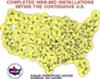
-Digital signal processing technology was introduced in the 1970s and 1980s, which allowed radar data to be analyzed more accurately. NEXRAD (Next Generation Weather Radar) was developed as a result, and it's still in use today.
-A phased array radar was developed in the 1990s and 2000s, which can scan a wide area quickly and detect changes in the atmosphere more quickly than traditional radar systems. In today's world, weather radar is an essential tool for meteorologists and forecasters, allowing them to track storms, monitor precipitation, and issue timely warnings.
 As another bonus, some types of even more modern radar have been designed to detect whether the object moving towards or away from the radar, and how fast. They call these Doppler Radar.
#6
How does Radar real-time Weather look?
Fixed objects, moving vehicles, storms, and sharp changes in weather conditions can be targets, causing unusual reflections called anomalous propagation, like the one described here at the US National Radar Weather page, and other things normally considered mistakes.
These weather radar real-time images provide information you can't get any other way. One thing they show is how fast and where the rain is falling.
Here are a few things to know about radar:
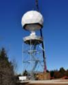
-Radar used to detect precipitation and other meteorological phenomena is a weather radar. The radar shoots out a beam of radio waves that bounce off objects in the atmosphere, then uses the reflected signal to map precipitation or other phenomena.
-There are different ways to display the information. The position plan indicator (PPI) shows the location of objects in the area being monitored on radar systems. A two-dimensional view of the area is shown, with distance on the horizontal axis and elevation on the vertical.
-A constant altitude plan position indicator (CAPPI) shows a slice of the atmosphere at a constant altitude. Meteorologists can see the precipitation distribution at a particular height.
-A mathematical constraint that determines the effectiveness of a radar is called the Nyquist interval: The Nyquist interval defines the minimum sampling rate required for capturing a signal accurately in digital signal processing. Nyquist intervals are equal to twice the signal's highest frequency.
Nyquist intervals are important in weather radar because they determine the minimum sampling rate to capture accurate reflectivity data. Radars may miss details in reflectivity data if the sampling rate is too low, so weather forecasts and warnings may be off.
Some additional info about Radar: Forecasters and people use the principles on this page to determine precipitation rates from radar power reflected. Check out this page to learn how Doppler radar equipment works.
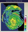
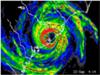
Here's a Canadian radar display from Calgary, Alberta.
Recent Articles
-
tornadoes
Feb 13, 26 12:37 AM
Here's a guide to power and storms from coconuts to cyclones - Ever wonder if you could fire your government like a bad intern or stop a tornado with a -
is air matter or not?
Feb 12, 26 12:30 AM
 You're swimming in a ton of air - There's a ton of invisible stuff crushing you right now, and you probably didn't even notice. Keep reading to find out
 -
how does popcorn pop
Feb 08, 26 07:08 PM
The Popcorn Paradox and How Your Snack Explains the Sky - You can hold a pressurized steam engine in your hand. It's actually a miniature bomb waiting
Real-Time Radar Weather - What's Happening in YOUR Region?
Real-time weather forecasts can be seen on the radar for immediate or emergency situations. Check out what's happening right now.
Do you have concerns about air pollution in your area??
Perhaps modelling air pollution will provide the answers to your question.
That is what I do on a full-time basis. Find out if it is necessary for your project.
Have your Say...
on the StuffintheAir facebook page
Other topics listed in these guides:
The Stuff-in-the-Air Site Map
And,
Thank you to my research and writing assistants, ChatGPT and WordTune, as well as Wombo and others for the images.
OpenAI's large-scale language generation model (and others provided by Google and Meta), helped generate this text. As soon as draft language is generated, the author reviews, edits, and revises it to their own liking and is responsible for the content.
You are here:
Most Popular Pages on this Website:
Pictures of Global Warming
- See photos, cartoons, charts, graphs and a few surprises.
Clouds
- Don't know a cumulus from a stratus? Check here.
Causes of Global Warming
- It's not always obvious.
Calgary Alberta Weather
- Example of Canadian Goodness.
Thermometers
- Our favourite weather instrument.
- Home
- Contact Us
- Free E-zine Back Issues
- Privacy Policy
- Site Map - I'll help find something good.
By Barry Lough, P.Met., EP (Environmental Professional)
Text copyright © 2003-2024 Stuff in the Air.com
BACK TO TOP - Hit your 'Home' Key
New! Comments
Do you like what you see here? Please let us know in the box below.