- Air Homepage
- Weather Satellites
- Live Picture Satellite
Live picture satellite instruments
Scientific principles work together to give us the live picture satellite illustration we see on news shows. Physics, optics, and electronics are included. Satellite imagery and computer processing combine to make a live picture of the Earth. The illustration then informs viewers about the current global situation. Weather satellite animations, for instance, show moving clouds on this map.
Find more about satellites.
Live satellite pictures: the physics behind them 🛰️Did you know that the beautiful live weather picture you see on the news is actually a mixture of visible sunlight and invisible heat? Find out how satellites use temperature and electromagnetic waves to capture real-time views of the whole planet instead of just watching clouds move.
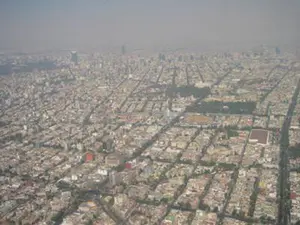
Here are some live satellite pics for North America. This still image was taken from an animated television display

Here's why the technology is so complicated.
Here are the Physics articles:
Physics tip #1 - Electromagnetic radiation comes from everything, which means that all objects, living or non-living, emit energy in the form of electromagnetic waves. Every object contains particles, like atoms and molecules, that are in constant motion and generate energy. The infrared portion of the electromagnetic spectrum is used by thermal imaging cameras to detect heat emitted by objects. An object's heat energy is directly related to its temperature and can be used to create a thermal image.
Physics tip #2 - Each body emits wavelengths, or a spectrum, that satellites can detect. To detect cloud formations and monitor weather patterns, weather satellites present different wavelengths as different colours of shades for us to interpret.
Physics tip #3 - Based on their temperature, objects have a peak wavelength they radiate stronger than all others. The sun has a peak wavelength in the visible light spectrum, while cooler objects like ice have a peak wavelength in the infrared spectrum. Objects radiate stronger at one wavelength than the others. Each pixel in the satellite image satellite image is dominated by one wavelength.
In this way, we can figure out what type of land cover is present in the image. One wavelength might indicate vegetation, while another might indicate water. The dominant wavelength mainly depends on the temperature of the object.
Physics tip #4 - Most objects reflect light and other radiation that strikes them from elsewhere. Sunlight reflected off a mirror is an example. Objects can also absorb or block certain wavelengths of radiation, creating shadows.
Physics tip #5 - The statement that each barrier is different means that each object will interact with radiation differently based on its composition and properties. You can see this in how different materials absorb and reflect different wavelengths of light, resulting in different colors and textures. Shadows are also created by bodies because of this blockage.
An interesting video on the limits of temperature and radiation can be found here.
Live Picture Satellite:
Temperature and spectrum of bright lines
In general, the higher the temperature of the radiating object, the smaller the wavelength. Thousands of degrees give off a broad range of light spectrum wavelengths with a peak intensity around half of one millionth of a meter (0.5 µm).

The earth's temperature ranges from 50 below to 100°F/40°C in the desert. Radiation from these parts of the earth has longer wavelengths and peaks around 11 µm. Satellites can detect energy radiating from the earth's surface. Radiative flux is what we use to measure the earth's temperature. Climate change can also be monitored and weather patterns can be predicted.
You can identify electromagnetic spectrum wavelengths with an electromagnetic spectrum chart. The chart helps you identify the different kinds of electromagnetic radiation and their wavelengths. You can also measure the intensity of the radiation by looking at the energy levels of the different wavelengths.
Satellites that show live pictures have devices to measure both ranges. We use visible sensors to see sunlight reflected by the surface and clouds, while infrared IR antennas take pictures from space using infrared light.
Then we get detailed cloud photos, moving cloud photos, and specialty cloud pics. It's not bad for a little device way up there.

#15
Search this site for more information now.
Electromagnetic Radiation Shielding
The atmosphere lets the sun's radiation through, but blocks various wavelengths of the earth's outgoing radiation. Due to the burning of wood, paper, and fuel as well as other atmospheric emissions, this phenomenon has been misnamed the the green house effect.
As a result, live picture satellites can detect radiation escaping through these window regions, wavelengths like 11 m that aren't stopped by the atmosphere. Satellite imagery can identify clouds because computers can convert IR intensity to temperature.
Also, if a camera designed to detect 6.7 µm is used, it shows where water vapor is. Water vapour absorbs this wavelength. Water molecules absorb the energy at this wavelength and convert it to heat, which is then released as infrared radiation. By detecting infrared radiation, the camera can tell where water vapour is.
Go back from Live Picture Satellite to the
Article Meteorology webpage. If you prefer, check out the Stuff in the
Air homepage.
Recent Articles
-
What causes pollution in the outside?
May 12, 26 12:44 AM
 The Hidden World of Pollution - Does the air you breathe have anything to do with a distant volcano or a dusty farm field? There's more to the gray haze
 -
UNDERWEAR AND POLLUTION
May 11, 26 12:12 AM
 Can Underwear Save the Earth? - What if your favorite pair of underwear were the only thing stopping a climate catastrophe? The hilarious truth about farts,
 -
Levi Mays Story about little boys
May 09, 26 07:06 PM
 The Secret History of Hot Air - Ever feel like there's more to what you see on the news? Get your detective gear on because we're diving into a world of
What is Live Picture Satellite? How does it work?
A live satellite presentation is often shown as part of a televised weather forecast. Why is this happening?
Do you have concerns about air pollution in your area??
Perhaps modelling air pollution will provide the answers to your question.
That is what I do on a full-time basis. Find out if it is necessary for your project.
Have your Say...
on the StuffintheAir facebook page
Other topics listed in these guides:
The Stuff-in-the-Air Site Map
And,
Thank you to my research and writing assistants, ChatGPT and WordTune, as well as Wombo and others for the images.
OpenAI's large-scale language generation model (and others provided by Google and Meta), helped generate this text. As soon as draft language is generated, the author reviews, edits, and revises it to their own liking and is responsible for the content.
By Barry Lough, P.Met., EP (Environmental Professional)
Text copyright © 2003-2024 Stuff in the Air.com
BACK TO TOP - Hit your 'Home' Key
New! Comments
Do you like what you see here? Please let us know in the box below.