Not What I expected
by Ruth Smith
(Boston, MA)


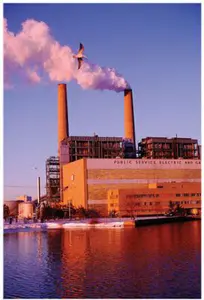
Charlotte before the snowstorm.
The first time I went to Charlotte, NC in January it was 70 degrees!
Now, they have snow and ice just like we do in New England!
Barry's Response - Yes, Ruth, the March 2009 snowstorm surprised a lot of people. There was a lot of snow this week in parts of the USA that don't get much! As far south as Alabama and Georgia.
NYC was another interesting target. The video shown at https://www.youtube.com/watch?v=BYZtVzSlKAE makes the city look like Edmonton or Saskatoon. With a 16 mph wind, it dropped to 12°F one night (-11°C) when most nights dip down to 30°F.
Atlanta hit 22°F too. At this time of year, it's usually about 40° at night. At that point, the wind had dropped from over 20 mph to about 8. It was 38° in New Orleans one night with 30 mph wind, when most nights are in the 50's.
What about Charlotte, North Carolina? The average low in early March is 40 degrees, but during this storm, it got down to 16 early on March 3. Several inches of snow came with it.
No match for Canada, though. Newfoundland once took a beating in 2003.
Search this site for more information now.
Perhaps I can explain the atmospheric dynamics involved in the relationship between winter storms and temperature extremes.
- During winter, polar air masses often invade regions with colder climates, causing winter storms. They bring frigid temperatures from the Arctic and can cause significant temperature drops.
- Low-pressure systems and frontal boundaries often accompany winter storms. Interactions with warmer air masses or encountering different air masses can cause rapid temperature changes. A cold front, for example, can bring colder air and drop the temperature abruptly.
- Winter storms often bring strong winds, which can make you feel colder. Temperature and wind speed combine to make the air feel colder on exposed skin than it really is.
- Winter storms can cause temperature inversions, where a layer of warm air is trapped above a layer of colder air near the ground. Temperature extremes can result from this inversion since the cold air stays trapped beneath the warmer layer.
Temperature extremes during winter storms are caused by a complex interplay of atmospheric conditions, air masses, frontal systems, and wind patterns. Also, we might talk about monitoring weather forecasts, preparing for extreme cold, and taking precautions to stay safe.
Comments for Not What I expected
|
||
|
||
|
Click here to add your own comments Join in and write your own page! It's easy to do. How? Simply click here to return to Cold, eh?. |
Recent Articles
-
the sun
May 17, 26 07:26 PM
 Cosmic Midlife Crisis: - Is the Sun Melting the Earth? Are you worried that the giant burning star in our sky is melting the Earth? Global warming isn't
 -
methane air pollution
May 16, 26 02:20 AM
 Methane is the secret smog maker - Gas from farm animals and garbage dumps can turn a blue sky into a brown soup? It turns out methane gas is linked to
 -
Global Warming Klan
May 15, 26 12:57 AM
 Planet Rescue: Real Action or Total Chaos? - Some people are so worried about the world that they come up with some pretty crazy ideas. Discover how kids

Do you have concerns about air pollution in your area??
Perhaps modelling air pollution will provide the answers to your question.
That is what I do on a full-time basis. Find out if it is necessary for your project.
Have your Say...
on the StuffintheAir facebook page
Other topics listed in these guides:
The Stuff-in-the-Air Site Map
And,
Thank you to my research and writing assistants, and the author remains responsible for the content.
Most Popular Pages on this Website:
Pictures of Global Warming
- See photos, cartoons, charts, graphs and a few surprises.
Clouds
- Don't know a cumulus from a stratus? Check here.
Causes of Global Warming
- It's not always obvious.
Calgary Alberta Weather
- Example of Canadian Goodness.
Thermometers
- Our favourite weather instrument.
- Home
- Contact Us
- Free E-zine Back Issues
- Privacy Policy
- Site Map - I'll help find something good.
By Barry Lough, P.Met., EP (Environmental Professional)
Text copyright © 2003-2024 Stuff in the Air.com
BACK TO TOP - Hit your 'Home' Key