Real Time Radar !
by D.T. Moffatt
(Grant Park IL. USA)
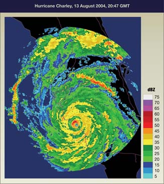
If you want to see real time weather reports go down to the Tampa Fl. area. They show up to the minute imageing that shows rotation of tornados coming in from the gulf and everything.
Why - in most other areas - do they think we want to see radar images from 3 hours ago?
Barry's Response - You're right. Some areas need up-to-the-minute weather details more than others.
An advanced radar technology, called phased-array radar, gives meteorologists a better temporal resolution. An even newer type of radar-forecasting-combo is called RAP. Severe weather can cause sudden changes that can catch observers off guard if they're using conventional equipment.
Generally, this technology uses antennas, reflected signals, algorithms, and software to detect patterns in data that wouldn't be obvious otherwise. Physicists call this constructive and destructive interference within an area of competing wave signals. Artificial Intelligence will serve to enhance this forecast technology as we progress.
It's more "cutting edge" than older radars in weather research and operational meteorology. The National Severe Storms Laboratory has used these extensively for projects in tornado alley. Every year we learn more about tornadoes and our ability to predict their motions.
That's money well spent.
Search this site for more radar information now.
What are the best real-time weather online access services?
Here are some of the best real-time weather apps in the US:
- The National Weather Service (NWS): The NWS provides official weather forecasts, warnings, and other weather-related info. Real-time weather updates are available on their website (weather.gov) and mobile apps.
- The Weather Channel: Get real-time weather forecasts, radar, and storm tracking on the Weather Channel's website and mobile apps. It's one of the most popular weather services.
- AccuWeather gives you real-time weather forecasts. Localized forecasts and detailed weather data are available. AccuWeather Canada also serves the territory up north.
- There's an interactive weather map, crowd-sourced weather data, and hyperlocal weather information at Weather Underground for US and Canadian viewers. I really like their interactive Wundermap.
- The Weather Channel's website offers weather forecasts, radar, and other weather-related stuff.
- Dark Sky: It's known for its minute-by-minute precipitation forecasts. Apple bought it and integrated its features into Apple Weather. This one serves Canadian locations as well.
- Weather.gov (National Oceanic and Atmospheric Administration - NOAA): This is the official weather site from NOAA.
Keep an eye out for new ones that come and go. Also, preferences for weather services can vary based on personal preferences and weather needs. Now for some widely-used and trusted Canadian weather services:
- ECCC - Weather.gc.ca: This is the official weather service of Canada. Various regions across the country can access real-time weather updates, forecasts, radar images, and weather warnings plus a variety of supplemental information.
- The Weather Network provides a popular source of weather information for Canadians. This website provides real-time weather forecasts, radar, and videos on various weather-related topics.
- WeatherCAN: This free app provides real-time weather forecasts, alerts, and other weather-related information from the Government of Canada.
As a meteorologist, I might emphasize the importance of using official government weather services, such as Environment and Climate Change Canada (ECCC listed above), as well as reputable sources, such as The Weather Network. During potentially hazardous weather events, consulting a variety of sources and staying informed about severe weather alerts and updates is a good idea.
Comments for Real Time Radar !
|
||
|
||
|
||
Do you have concerns about air pollution in your area??
Perhaps modelling air pollution will provide the answers to your question.
That is what I do on a full-time basis. Find out if it is necessary for your project.
Have your Say...
on the StuffintheAir facebook page
Other topics listed in these guides:
The Stuff-in-the-Air Site Map
And,
Thank you to my research and writing assistants, ChatGPT and WordTune, as well as Wombo and others for the images.
OpenAI's large-scale language generation model (and others provided by Google and Meta), helped generate this text. As soon as draft language is generated, the author reviews, edits, and revises it to their own liking and is responsible for the content.


