- Air Homepage
- Upper Atmosphere
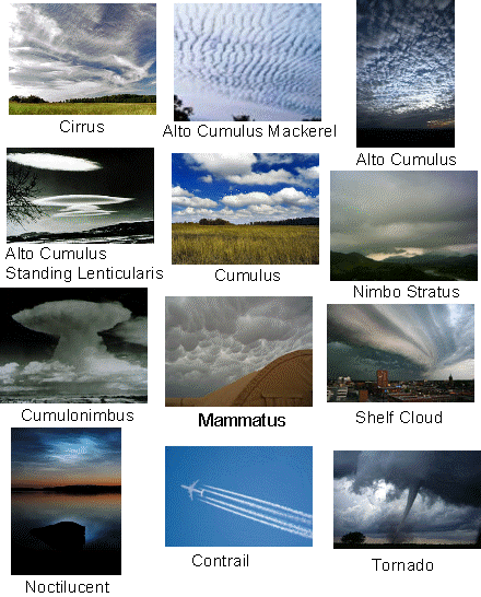
- Different Types of Clouds
How Different Types of Clouds Form: The Air Motions Behind the Sky
Have you ever looked up and wondered why one day the sky is filled different types of clouds? Maybe flat, gray clouds while another day produces huge towers of white cloud?
The answer is air motion.
Clouds are not just shapes floating randomly overhead. Their size, shape, height, and even whether they produce rain or thunderstorms tell us something about what the atmosphere is doing. A towering cumulonimbus cloud tells a very different story from a thin sheet of cirrus or a flat layer of stratus.
The big idea is surprisingly simple:
Clouds form when air rises, cools, and becomes moist enough for water vapour to condense. What happens next depends largely on how stable the surrounding atmosphere is.
Understanding that connection gives you a way to look at clouds and make an educated guess about what the atmosphere is doing—even before looking at a weather forecast.
Understanding different types of clouds is important for producing weather forecasts, air quality assessments and climate studies
The four families for Different types of clouds
Cloud name
What it generally looks like
What it tells you
Cirrus
Thin, wispy, feather-like
High in the atmosphere
Stratus
Flat, widespread layers
Air is relatively stable
Cumulus
Puffy, piled-up clouds
Air is rising
Cumulonimbus
Huge towers, often with an anvil top
Strong upward motion and thunderstorms
Other names are built by combining these basic terms.
Altocumulus, for example, means a cumulus-like cloud at middle levels of the atmosphere.
Nimbostratus is a widespread cloud associated with prolonged precipitation.
And cumulonimbus is the giant cloud associated with thunderstorms.
Then there are different types of clouds. Lenticular clouds, for example, can form near mountains when moving air is forced over terrain and sets up a wave pattern.
So why do clouds take such different forms? To answer that, we have to look at the invisible air around them.
Clouds are clues to what the atmosphere is doing
Clouds form when moist air rises and cools.
As the air cools, it eventually reaches a point where water vapour begins to condense into tiny water droplets or ice crystals. That is the basic recipe for a cloud:
Moisture + cooling + upward motion = cloud
But there is another ingredient that determines whether that cloud stays flat, spreads out or shoots upward: atmospheric stability.
Think of stability as the atmosphere's tendency to resist or encourage vertical movement. A simple way to picture it is with a ball.
A ball in a bowl: stable air
Imagine placing a ball in the bottom of a bowl. Push it upward and it rolls back down. Push it sideways and it eventually returns to the bottom.
That is similar to stable air. If a parcel of air is pushed upward, the surrounding atmosphere tends to push it back toward where it started. Stable conditions often favour flatter clouds such as stratus or can suppress cloud development altogether.
A ball on a hill: unstable air
Now put the ball on top of a hill. Give it a tiny push and it rolls away. Air can behave in a similar way in an unstable atmosphere.
Once an air parcel begins rising, it can continue rising because it remains warmer and less dense than the surrounding air.
That encourages clouds to grow vertically. This is how small puffy cumulus clouds can sometimes develop into enormous cumulonimbus thunderstorms.
A ball on flat ground: neutral air
Now imagine the ball sitting on a perfectly flat surface. Push it and it stays where you put it.
That is roughly analogous to neutral stability. A displaced parcel of air has little tendency either to return to its original position or to accelerate away from it.
Why rising air makes clouds
Here's the part that makes the whole system work. Air pressure decreases as you go higher in the atmosphere. When a parcel of air rises, it expands. Expanding air cools.
If the air contains enough moisture, eventually it cools to the point where the water vapour begins to condense.
Tiny droplets or ice crystals form. A cloud appears.
This is why lifting is so important in meteorology. Air can be lifted in several ways:
- Convection — the ground warms the air above it.
- Mountains — terrain forces air upward.
- Weather fronts — one air mass is forced over another.
- Convergence — air flowing together has nowhere to go but upward.
- Thunderstorms — strong buoyant air rises rapidly through the atmosphere.
Different types of lifting produce different cloud patterns. That gives us an important clue:
To understand a cloud, don't just look at the cloud. Ask what is making the air move.
Stable air: when the atmosphere puts the brakes on
In stable air, vertical motion is suppressed. Imagine trying to push a beach ball underwater. The surrounding water pushes it back upward.
The atmosphere can similarly resist the vertical movement of an air parcel. Stable conditions tend to produce relatively gentle, widespread cloud formations. You may see:
- Stratus
- Nimbostratus
- Fog
- Low cloud layers
- Sometimes high, thin cloud such as cirrus
Stable air can also be associated with temperature inversions. An inversion occurs when temperature increases with height through a layer of the atmosphere rather than decreasing normally.
That can act like a lid, limiting vertical mixing. And this matters far beyond clouds.
Air-quality meteorologists care about stability because stable air can limit vertical dispersion and allow pollutants to become concentrated near the ground. This is one of the places where weather and air-quality science meet.
Unstable air: when clouds grow upward
Unstable air is a completely different story.
When an air parcel rises, it may remain warmer and less dense than the surrounding atmosphere. Instead of being pushed back down, it continues upward.
The result can be vigorous convection. Small cumulus clouds may grow into towering clouds.
If the atmosphere contains enough moisture and the upward motion becomes strong enough, the result can be a thunderstorm.
A mature cumulonimbus cloud can contain powerful updrafts and downdrafts. It can produce:
- Heavy rain
- Lightning
- Thunder
- Strong winds
- Hail
- Sometimes tornadoes
The enormous vertical size of the cloud is therefore a visible clue that the atmosphere is allowing air to rise vigorously.
What does moisture have to do with stability?
Here's where things become a little more interesting. Moist air and dry air do not cool at exactly the same rate when they rise. Unsaturated air cools according to the dry adiabatic lapse rate.
Once an air parcel becomes saturated, condensation begins. Condensation releases latent heat, which slows the rate at which the rising parcel cools.
That means a saturated parcel can remain warmer than it otherwise would. And a warmer parcel has a better chance of continuing to rise.
This is one reason moist, unstable air can be such powerful fuel for thunderstorms. You don't need to memorize the equations to understand the important idea: Water vapour can help turn rising air into stronger rising air.
A little meteorological detective work
Meteorologists can investigate this invisible structure of the atmosphere using instruments and thermodynamic diagrams.
Take a look at the drawing in this sample, right below the thunderstorm photo. It shows a portion of a skew-T, log-P chart.
One of the most useful tools is the Skew-T Log-P diagram, also known as a type of thermodynamic sounding diagram.
It shows how temperature, pressur and moisture change with height. Meteorologists can use it to investigate questions such as:
- Is the atmosphere stable or unstable?
- At what height will clouds form?
- How high might a cloud grow?
- Is there enough moisture for thunderstorms?
- Is there a temperature inversion?
- How strong might convection become?
 Dynamic weather and air-parcel motion
The diagram contains lines called adiabats. An adiabat shows how an air parcel's temperature changes as it rises or sinks without exchanging heat with its surroundings.
A dry, unsaturated parcel follows a dry adiabat. Once it becomes saturated, it follows a moist or saturated adiabat.
Comparing the temperature of the air parcel with the temperature of the surrounding atmosphere tells meteorologists whether the parcel is likely to keep rising or return toward its original level.
If you want to go deeper, this is where a fascinating part of meteorology begins: you can learn to read the atmosphere vertically rather than simply looking at a weather map.
The three basic stability categories
Meteorologists commonly describe atmospheric stability in three broad ways.
Absolutely stable - A displaced air parcel tends to return toward its original level whether it is dry or saturated.
Vertical motion is suppressed. And the atmosphere may favour:
- Layered clouds
- Fog
- Stratus
- Limited vertical mixing
Absolutely unstable - A displaced parcel continues to move away from its original level whether it is dry or saturated.
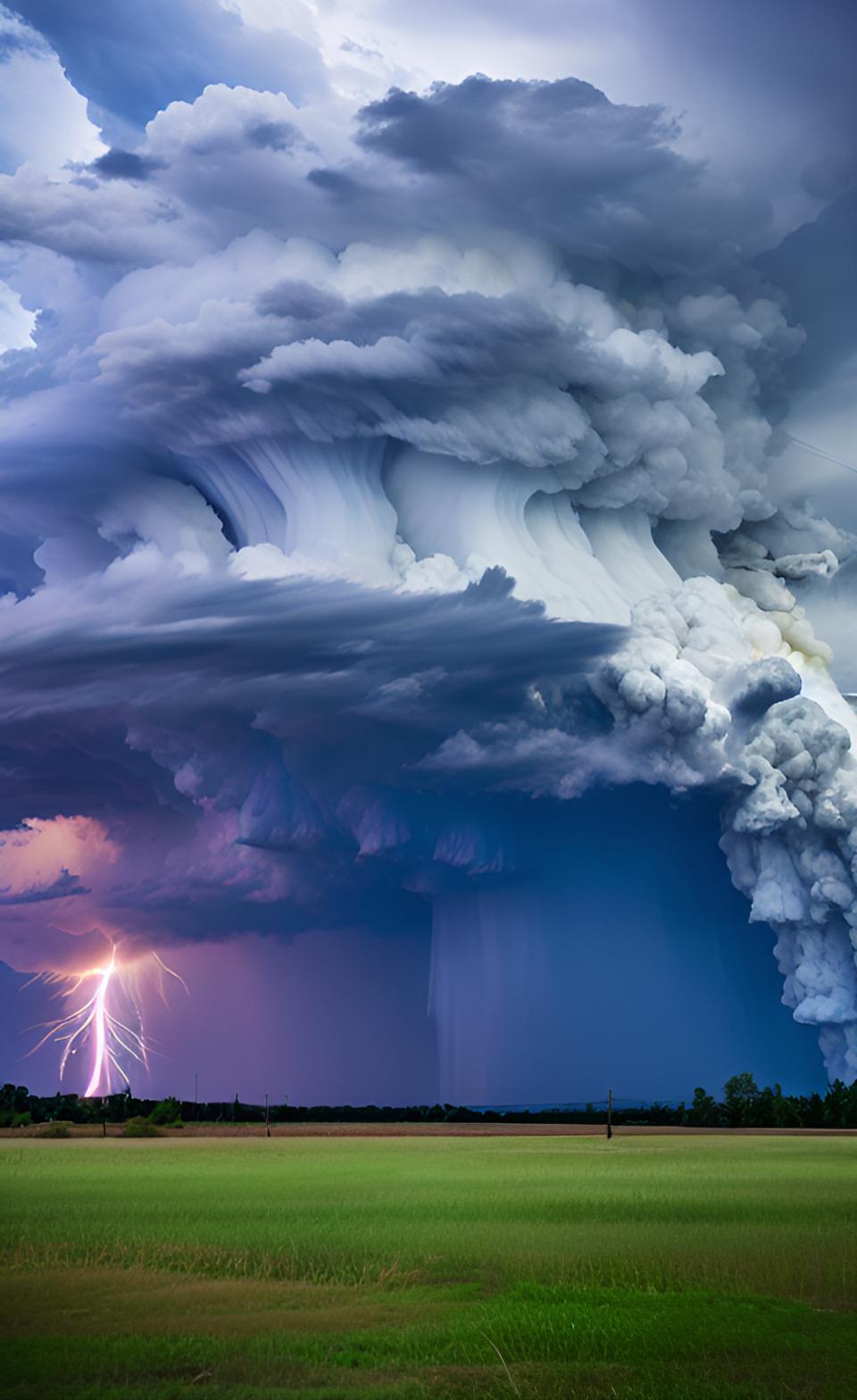 What causes Thunder and Lightning?
This condition is rare and usually short-lived in the real atmosphere.
Strong heating from below can temporarily produce extremely steep temperature gradients, but mixing and turbulence tend to work against maintaining such conditions.
Conditionally unstable - This is one of the most important situations for real weather. The atmosphere may be stable for a dry air parcel but unstable once the parcel becomes saturated.
That means a parcel might initially resist rising. But if something lifts it high enough to become saturated, condensation begins, latent heat is released and the parcel can become increasingly buoyant.
This helps explain why thunderstorms can suddenly develop when the right combination of moisture, heating and lifting comes together.
From Clouds to Thunderstorms
Imagine a warm summer afternoon. The sun heats the ground. The ground heats the air immediately above it.
That warm air begins to rise. As it rises, it expands and cools. Eventually it reaches saturation.
A small cumulus cloud appears. If the atmosphere above is stable, the cloud may stop growing. If the atmosphere is unstable and there is plenty of moisture, the rising air can continue upward.
The cloud grows taller. More condensation releases more latent heat. The rising air becomes increasingly buoyant.
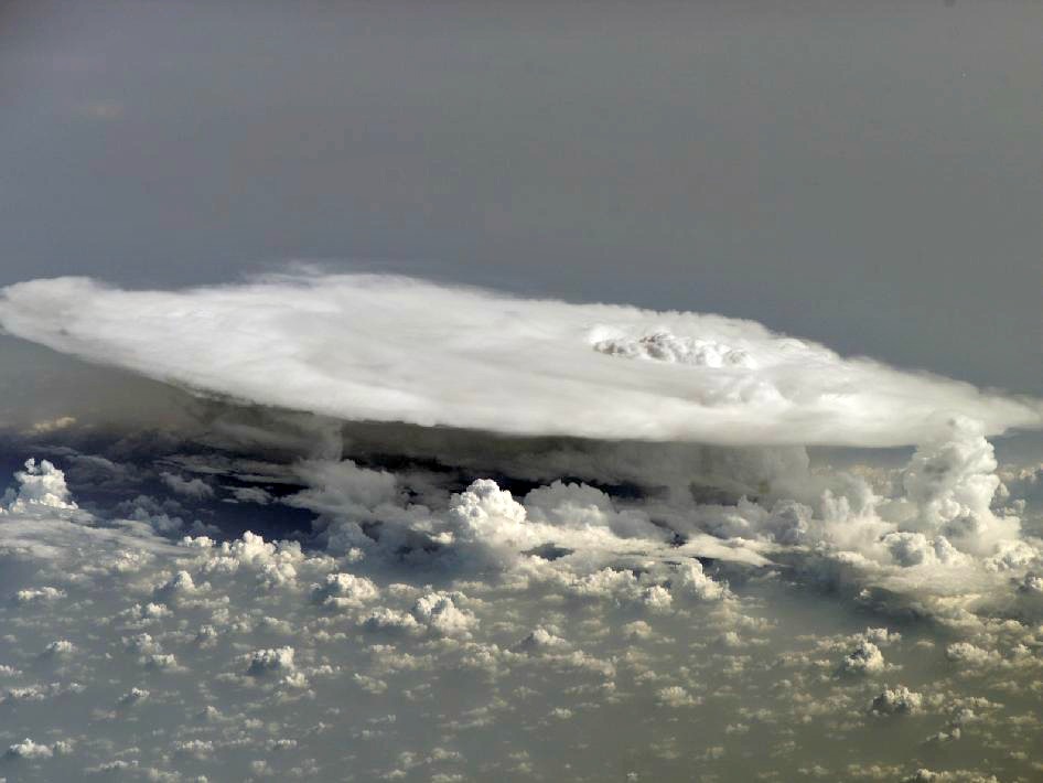
The cloud grows taller still. Eventually, a towering cumulonimbus may develop.This is one reason meteorologists pay close attention to temperature, moisture and stability together rather than looking at any one measurement in isolation.
What is "absolute instability"?
Absolute instability is an interesting theoretical extreme. Imagine an atmosphere where temperature decreases extremely rapidly with height.
Air parcels moving upward would remain warmer than their surroundings and would continue accelerating upward. That sounds like a recipe for spectacular clouds.
But the atmosphere usually doesn't allow such a situation to persist for long.
Strong vertical motions create turbulence and mixing. The mixing changes the temperature structure and tends to reduce the extreme instability.
Strong heating from below can briefly create very steep temperature gradients. Examples include:
- Cold air moving over a warm lake
- Intense sunshine heating the ground
- Strong heat from a wildfire
The resulting turbulence works to mix the atmosphere.
So the atmosphere has an interesting habit: when conditions become extremely unstable, the resulting motion tends to change the conditions that created the instability in the first place.
What clouds can tell you about the weather
Once you understand the connection between cloud shape and air motion, looking at the sky becomes a little like reading a weather map.
Thin, wispy cirrus - High clouds can signal moisture and changing conditions high in the atmosphere.
Flat stratus - A broad, layered cloud deck suggests relatively stable air and limited vertical motion.
Puffy cumulus - Cumulus clouds are clues that air is rising locally. Small fair-weather cumulus may remain shallow.
Rapidly growing cumulus can be a warning that convection is becoming stronger.
Towering cumulonimbus - A huge vertical cloud indicates powerful upward motion and potentially severe weather.
Lenticular clouds - Lens-shaped clouds near mountains reveal something particularly interesting: the atmosphere is interacting with terrain and producing waves in the airflow.
Once you know what to look for, the sky becomes a giant atmospheric laboratory.
And here's where air quality enters the picture
The same atmospheric stability that controls cloud development also affects how pollutants move. That's why meteorologists and air-quality modellers pay close attention to the vertical structure of the atmosphere.
In stable conditions, vertical mixing can be weak. Pollutants released near the surface may remain concentrated.
In more turbulent conditions, pollutants can mix through a deeper layer of atmosphere. So the question isn't simply:
"How much pollution is being emitted?"
It can also be:
"What is the atmosphere doing with it?"
This is one of the fundamental connections between meteorology and air-quality dispersion modelling.
The atmosphere doesn't behave like an empty box. Temperature, wind, turbulence, terrain, stability and atmospheric mixing all influence where an emitted pollutant goes.
If that connection interests you, explore the site's material on atmospheric stability, temperature inversions, convection, wind and air-quality modelling. The same physics that makes a cloud grow—or disappear—also helps determine how pollution disperses.
Try being a cloud detective
The next time you look at the sky, don't just ask: "What kind of cloud is that?" Ask a few more questions about these different types of clouds.
1. Is the cloud flat or growing vertically?
Flat often suggests more stable conditions. Vertical growth suggests stronger upward motion.
2. Is it getting taller?
Rapid growth can indicate increasing instability.
3. Is there a temperature inversion?
An inversion can put a lid on vertical motion.
4. Where is the moisture coming from?
Moisture may be transported by wind, supplied by evaporation or concentrated near the surface.
5. What is forcing the air upward?
Is the sun heating the ground? Is a mountain forcing the air upward? Is a front approaching? Is air converging?
Those questions take you from simply identifying different types of clouds to actually understanding the atmosphere.
Keep exploring the atmosphere
Different types of clouds are one of the easiest ways to start learning meteorology because they're visible. But the most interesting parts of the atmosphere are often invisible.
If you enjoyed this article, explore next:
How thunderstorms form — Follow a cloud from its first small cumulus bubbles to a towering cumulonimbus.
How temperature inversions work — Discover why a layer of warmer air can trap colder air and pollutants near the ground.
Convection currents — See how heat creates rising and sinking air and drives some of the atmosphere's most important motions.
Dew point and humidity — Learn why meteorologists use dew point to understand how much moisture is actually in the air.
Wind and terrain — Find out how mountains and other features reshape airflow.
air quality dispersion modelling — Take the next step and see how the same meteorology is used to predict where industrial emissions will travel.
And if you want to go deeper still, learn to read a Skew-T Log-P diagram. Once you can look at temperature and moisture profiles and visualize what an air parcel is going to do, a weather sounding stops looking like a collection of mysterious lines and starts telling you a story about the atmosphere.
The big idea
A cloud is more than a pretty object in the sky. It is evidence of what the atmosphere is doing.

#34
Stable air → limited vertical motion → layered clouds or clear skies.
Unstable air → rising motion → growing cumulus clouds and potentially thunderstorms.
Moisture + lifting → cooling → condensation → clouds.
And those same principles help meteorologists understand weather, thunderstorms, fog, temperature inversions and even the movement of air pollution.
So the next time you look up, take another minute. Don't just identify the different types of clouds. Read the atmosphere.
Recent Articles


-
Energy and Environment: Persuading industry to care
Sep 15, 26 02:47 PM
 What's wrong with Alberta's energy and environment? International media criticize the province and its biggest industry almost every day. Here's the truth.
 -
AERMOD Air Quality Modelling in Alberta
Sep 14, 26 05:58 PM
 Can you tell me which air quality model works best for most Alberta Air Quality Model Guideline regulatory modeling? AERMOD. It's easy, versatile, and recognizable.
 -
Air Dispersion Model - What's an air model?
Sep 14, 26 02:13 PM
How do we help a factory control air pollution? Provide design feedback ahead of time using an air dispersion model.

Cloud Types | How Many Do You Know?
Different air motions produce different types of clouds. We see clouds formed by air moving up and down.
Do you have concerns about air pollution in your area??
Perhaps modelling air pollution will provide the answers to your question.
That is what I do on a full-time basis. Find out if it is necessary for your project.
Have your Say...
on the StuffintheAir facebook page
Other topics listed in these guides:
The Stuff-in-the-Air Site Map
And,
Thank you to my research and writing assistants, and the author remains responsible for the content.
You are here:
Most Popular Pages on this Website:
Pictures of Global Warming
- See photos, cartoons, charts, graphs and a few surprises.
Clouds
- Don't know a cumulus from a stratus? Check here.
Causes of Global Warming
- It's not always obvious.
Calgary Alberta Weather
- Example of Canadian Goodness.
Thermometers
- Our favourite weather instrument.
- Home
- Contact Us
- Free E-zine Back Issues
- Privacy Policy
- Site Map - I'll help find something good.

By Barry Lough, P.Met., EP (Environmental Professional)
Text copyright © 2003-2026 Stuff in the Air.com
BACK TO TOP - Hit your 'Home' Key